Menu
  • Home
  • Breaking News
  • Feature
    • Arts
    • Astrology
    • Business
    • Community
    • Employment
    • Event Stories
    • From the Pioneer
    • Government
    • Letters to the Editor
    • Non Profit News
    • Obituary
    • Public Safety
    • Podcast Interview Articles
    • Pioneer Pulse Podcast: Politics, Palette, and Planet – the Playlist
  • Weather
  • Guest Column
    • Perspectives
    • Don Backman Photos
    • Ardent Gourmet
    • Kitchen Maven
    • I’ve been thinking
    • Jim Heffernan
    • The Littoral Life
    • Neal Lemery
    • View From Here
    • Virginia Carrell Prowell
    • Words of Wisdom
  • Things to do
    • Calendar
    • Tillamook County Parks
    • Tillamook County Hikes
    • Whale Watching
    • Tillamook County Library
    • SOS Community Calendar
  • About
    • Contribute
    • Advertise
    • Subscribe
    • Opt-out preferences
  • Post Submission Test
  • Search...
Menu

GORDON’S WEEKLY WEATHER UPDATE 12/23/24: Christmas Travel Concerns; Next Week could be Ugly, Too …

Posted on December 23, 2024 by Editor

By Gordon McCraw, Meteorologist for the Tillamook County Pioneer

Now remember folks, I’m just the friendly messenger! I thought I would give an update on the weather for the current Atmospheric River event, and alert you of another potentially significant weather event shaping up for next week during the New Year holiday period.

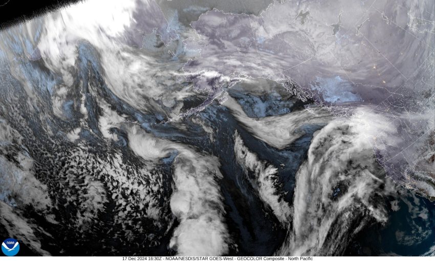
First, let’s deal with the current event. If you look at the satellite picture, you can see the frontal system is lifting into the area that is transporting some subtropical moisture that will enhance the rain rates for the area. It appears the Coast Range is looking at 3 to 4” of rain over the next 24hr period. While this will increase the river levels, river flooding concerns remain low … for now!

As the front moves in across the area, the winds are expected to increase, becoming southerly 14-18 gusting to 40-45 this afternoon and evening, then westerly 15-20 gusting to 25 after midnight as they continue to ease in the early morning hours. As is the case in most of these events, the winds at the coast will be higher, with gusts to 50-60 possible at the beaches and headlands. This has prompted the National Weather Service to issue a High Wind Warning for the coastal area from noon today through 4am tomorrow morning.

We have the associated cold front pushing across tomorrow morning then things ease later tomorrow morning with a 50% chance of mainly light rain still on Thursday into Friday morning as other systems pass near the area.

It still looks like we will be under a southwesterly flow for the weekend that could push some disturbances and the associated rain across the area over the weekend.

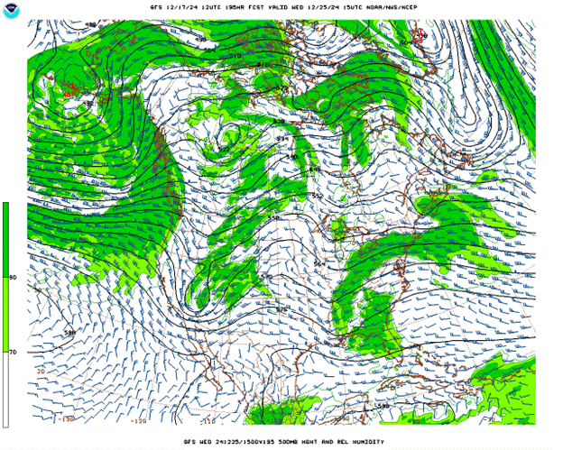
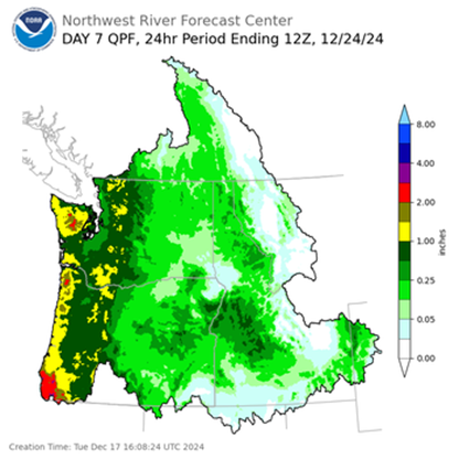
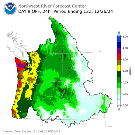
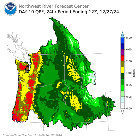
Now for the bad news, the extended models are showing another Atmospheric River event is possible next week, potentially spinning up some surface low pressure areas, that will being high winds and heavy rains over the Christmas holiday period. I have included some of the current modeling data that support this. In addition to this, the National Weather Service and the Climate Prediction Center are now suggesting that there is an increasing chance for an Atmospheric River event to impact the Holiday Travel Period. Their numbers say there is a 40-60% chance of heavy rain for the period of December 24, 26 and 27. There is also a moderate risk of high wind events associated with these systems. The heavy rains have the potential to cause Urban and Small Stream Flooding and also have the potential to lead to river flooding as well though at this time, it appears the threat is higher south of Tillamook County.

So, I explain all this now so you are aware that these conditions could negatively impact travel conditions over the Christmas Holiday period. As usual, this far out, things can change, both for the better, or for the worse. The bad news, for now, is that several of the models are in agreement. The bottom line, Stay Tuned as the exact location, timing and strength for all the heavier stuff is unclear this far out.

Featured Video

Slide Contribute SUBSCRIBE

Tillamook Weather

Tides

Tillamook County Pioneer Podcast Series

Tillamook Church Search

Cloverdale Baptist Church
Nestucca Valley Presbyterian
Tillamook Ecumenical Service

Archives

  • Home
  • EULA Privacy Policy
  • Contact
  • Opt-out preferences
  • Search...
Share on facebook
Facebook
Share on pinterest
Pinterest
Share on twitter
Twitter
Share on linkedin
Linkedin
Catherine

Recent Posts

  • NEHALEM BAY STATE PARK TO OPEN DAY-USE AREAS, BOAT LAUNCH MAY 23, CAMPGROUND REMAINS CLOSED

    May 14, 2025
  • MANZANITA FARMERS MARKET OPENS FRIDAY MAY 16TH!!

    May 14, 2025
  • Vote NO on Increasing Taxes in Tillamook County

    May 14, 2025
©2025 | Theme by SuperbThemes

Manage Cookie Consent
To provide the best experiences, we use technologies like cookies to store and/or access device information. Consenting to these technologies will allow us to process data such as browsing behavior or unique IDs on this site. Not consenting or withdrawing consent, may adversely affect certain features and functions.
Functional Always active
The technical storage or access is strictly necessary for the legitimate purpose of enabling the use of a specific service explicitly requested by the subscriber or user, or for the sole purpose of carrying out the transmission of a communication over an electronic communications network.
Preferences
The technical storage or access is necessary for the legitimate purpose of storing preferences that are not requested by the subscriber or user.
Statistics
The technical storage or access that is used exclusively for statistical purposes. The technical storage or access that is used exclusively for anonymous statistical purposes. Without a subpoena, voluntary compliance on the part of your Internet Service Provider, or additional records from a third party, information stored or retrieved for this purpose alone cannot usually be used to identify you.
Marketing
The technical storage or access is required to create user profiles to send advertising, or to track the user on a website or across several websites for similar marketing purposes.
Manage options Manage services Manage {vendor_count} vendors Read more about these purposes
View preferences
{title} {title} {title}