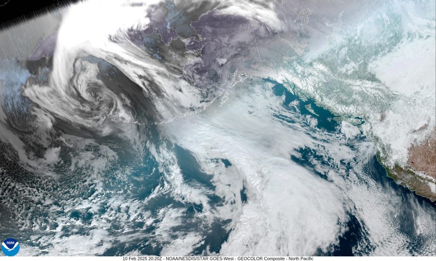
By Gordon McCraw, Meteorologist for the Tillamook County Pioneer
A cold, foggy start to the day with the morning lows under mostly clear skies, dropping to near 28 degrees. Now we see some easterly winds starting to move in that will further dry things out but also pushes in some Arctic air from east of the Cascades. Add this to the clear skies tonight providing some radiational cooling, and you get low temperatures dropping to around 21 tonight.
Tomorrow is another nice, but cold day with sunny skies and light east winds, the high only makes it to 41. The clear skies tomorrow night with those light east winds allows the temperature to again drop to near 23.
Now Wednesday things start out okay with sunny skies, still light easterly winds, the afternoon high near 43. Then things take a turn with increasing clouds signaling an approaching warm front and its associated low pressure area that will make things a little dicey starting late that night. We could see some precipitation moving in during the early morning hours. The problem is the easterly surface winds will still cause the early morning temperatures to drop to near 26 that night. This means we could see some lower level snow.
As the temperatures above the surface begin to warm, the chance of snow changes later Thursday morning to a chance of freezing rain until the surface temperatures climb to above freezing, sometime around noon when it turns to all rain. The cycle continues Thursday night with rain likely still, then the temperature falls to below freezing at the surface, around 8pm that night, leading to freezing rain and sleet once again through the early morning hours with the low dropping to near 29.
So, we start out with that chance of freezing rain or sleet Friday morning under partly sunny skies. Again as the temperatures warm above freezing at the surface late morning, then the precipitation turns to just rain, the afternoon high near 46. We are now watching another system approaching the area from the northwest that brings another round of rain that persists through the weekend. The good news is the temperature will be rising some with afternoon highs in the upper 40s and nighttime lows staying above freezing.
So, to summarize, it looks like we are dry and cold though Wednesday with that cold air locked over us through at least Thursday. We are looking at mainly some light precipitation amounts but with the low temperatures, it will start out as snow, then transition to a mix of snow and sleet, then over to freezing rain Wednesday night into Thursday and again on Friday. The precipitation could come in waves so giving the exact start/stop times becomes difficult, and there is some question to exactly when the temperature climbs to above freezing on Thursday. The other unknown is the next system expected on Friday. Where will its impact be and how strong of a system when it moves in. It is unlikely that we see freezing rain from this system as the temperatures are expected to remain above freezing, though the chances are not a zero percent chance.
Now, some additional information for Hwy 6. High temperatures there are expected to be plus/minus 32 through Wednesday with overnight lows dropping into the teens. You can expect to see snow over the pass Thursday with a chance of snow, or sleet, or freezing rain Friday and Friday night though the snow level will be rising Friday night. By Saturdayl there will be a chance of freezing rain until the temperature rises to above freezing then stays as rain the rest of the weekend. Lastly, remember, icing on the roads, no matter how light, makes driving hazardous for you, and others. Know before you go, look at the weather, and at Tripcheck before you head out the door!
COLD WEATHER ADVISORY REMAINS IN EFFECT FROM 7 PM THIS EVENING 2/10/25 TO NOON PST TUESDAY 2/11/25
* WHAT…Very cold temperatures as low as 15 to 25 degrees are expected.
* WHERE…Greater Portland/Vancouver Metro, Central and Southern Willamette Valley, South Washington, and North and Central Oregon Coast, Northern, and Central Coast Range Valleys and Mountains of Oregon, Foothills of the Northern and Central Oregon Cascades, Willapa Hills and Adjacent River Valleys of Pacific and Wahkiakum Counties, Lower Columbia River and Cowlitz River Valleys, and South Washington Cascade Foothills.
Frostbite and hypothermia will occur if unprotected skin is exposed to these temperatures. Very cold temperatures can lead to hypothermia with prolonged exposure.


