
Tillamook County Pioneer

News & People of Tillamook County. Every Day.

Menu
  • Home
  • Feature
    • Breaking News
    • Arts
    • Astrology
    • Business
    • Community
    • Employment
    • Event Stories
    • From the Pioneer
    • Government
    • Letters to the Editor
    • Non Profit News
    • Obituary
    • Public Safety
    • Podcast Interview Articles
    • Pioneer Pulse Podcast: Politics, Palette, and Planet – the Playlist
  • Guest Column
    • Perspectives
    • Don Backman Photos
    • Ardent Gourmet
    • Kitchen Maven
    • I’ve been thinking
    • Jim Heffernan
    • The Littoral Life
    • Neal Lemery
    • View From Here
    • Virginia Carrell Prowell
    • Words of Wisdom
    • Chuck McLaughlin – 1928 to 2025
  • Weather
  • Post Submission
  • Things to do
    • Calendar
    • Tillamook County Parks
    • Tillamook County Hikes
    • Whale Watching
    • Tillamook County Library
    • SOS Community Calendar
  • About
    • Contribute
    • Advertise
    • Subscribe
    • Opt-out preferences
  • Search...
Menu

GORDON’S WINTER WEATHER OUTLOOK 2026-27

Posted on September 24, 2026 by Editor


By Gordon McCraw, Meteorologist for the Tillamook County Pioneer
So, Tuesday was officially the first day of fall as the sun has crossed the equator, moving into the Southern Hemisphere. As such, I thought it would be a good time to give you my take on what we can expect, generally, for this winter’s weather.

First, let’s look at what the latest El Nino/Southern Oscillation (ENSO) Diagnostic Discussion issued September 10th says. As you may recall, it was looking like this years El Nino was expected to be one of the strongest in many years. Well, it is indeed strengthening with the Climate Prediction Center saying it has a 90% chance of becoming a very strong event for the Northern Hemisphere’s fall and winter months (2026-2027). Their models take multiple models and feed these into another combined model, that does indicate that the El Nino will continue to strengthen through the end of the year. They also say there is a good chance this could be the strongest event since the 1950s.

Now for us folks here in the Pacific Northwest, El Nino events typically bring warmer than average temperatures with a high chance of seeing dry conditions that would also mean seeing reduced snowpack in the Cascades. This is because El Nino pushes the jet stream, that is the vehicle that pushes the weather systems in, further southward into southern California. Other impacts from this pattern could be, increasing the drought risk, which in turn will increase the wildfire risks this next fire season. It would also limit the coastal upwelling which brings up the deep, nutrient rich water that the fish feed on. This could, or would, disrupt fishing in this area. Now, having said all this, the Climate folks point out that these negative impacts are not guaranteed, only that the odds are better that this will happen.

So, what about our winter season forecast? The Climate Prediction Center, in their Seasonal Outlook, that was issued on September 17th, covering October-November-December, show an equal chance of seeing Above or Below Normal Precipitation for this period. It was also leaning to about a 35% chance of seeing above normal temperatures. As you move eastward into the valley and then into eastern Oregon, the chances increase with better than a 50% chance of above normal temperatures in the high desert. Moving back into the end of September and the beginning of October though, it shows a slight chance of seeing above normal Precipitation, with near normal temperatures expected.
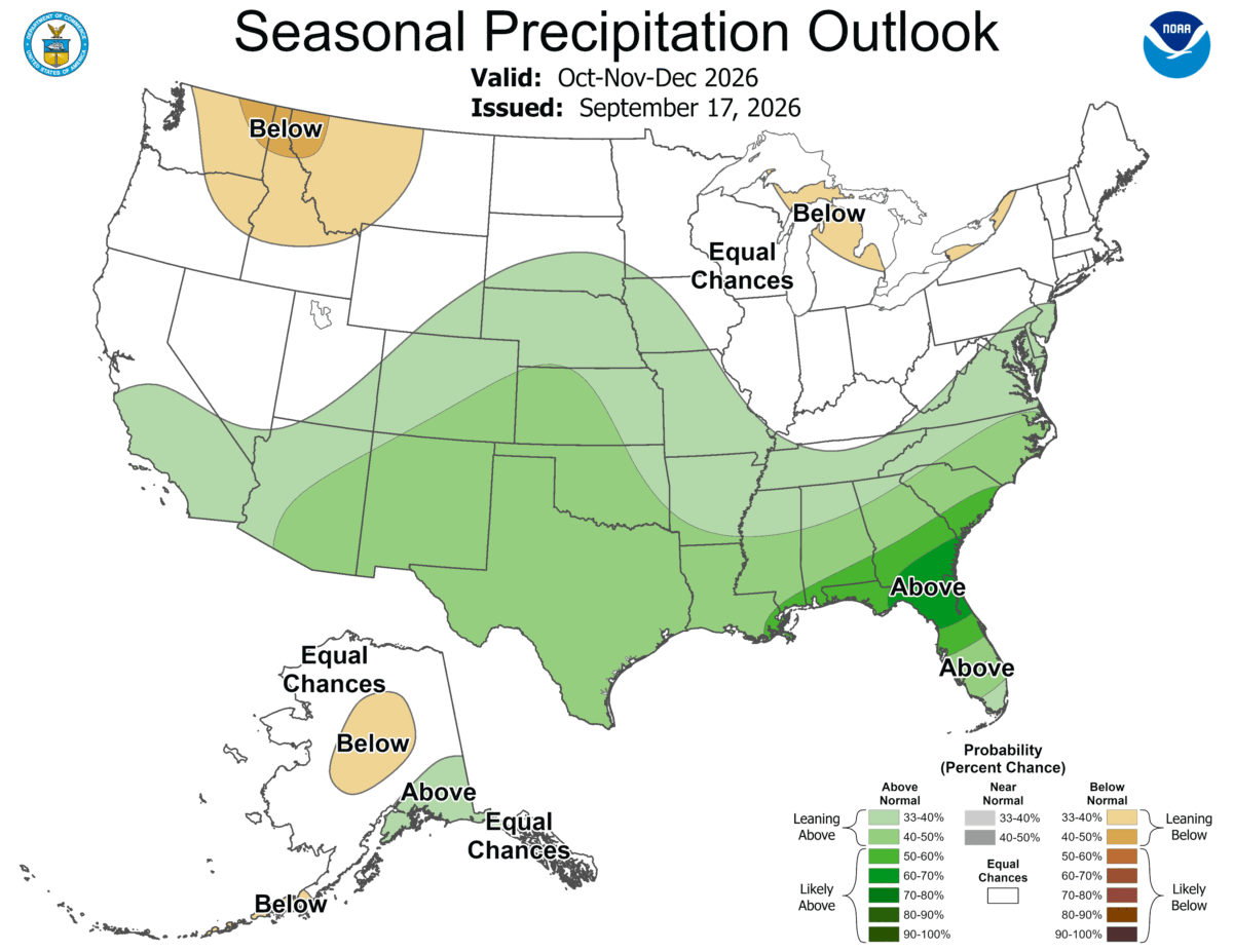
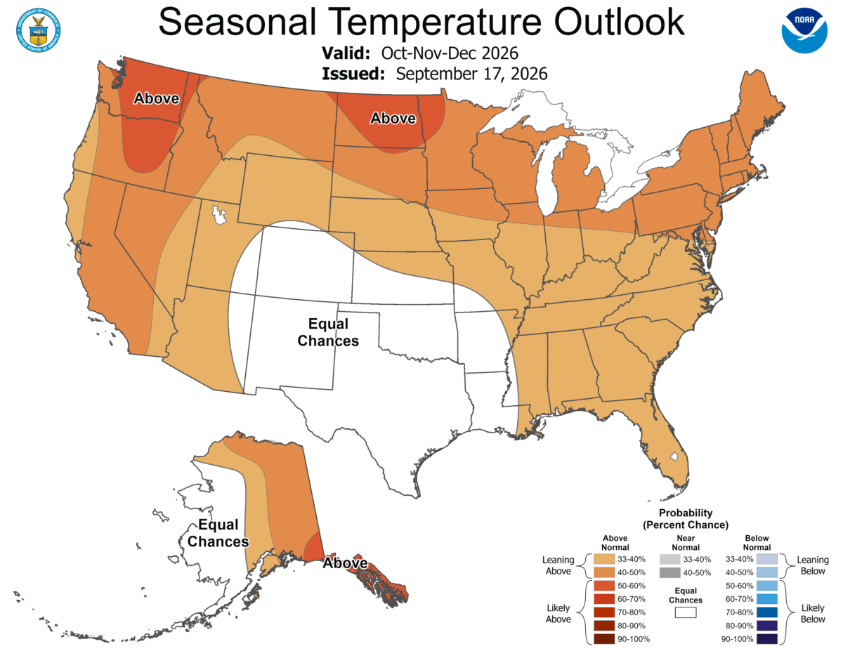
And what does all this mean. As one of the Portland NWS Forecasters used to say, it doesn’t mean these conditions will occur. It just means that if you are a betting person, you want to put more chips on them occurring, than you put on the stack for them not occurring. I will also point out that the major flood event in November of 2006 that gave us Hurricane force winds and 20” of rain causing record crest on the Wilson River, was during an El Nino year. And, like I used to say in my Hurricane briefs in Louisiana, if you had a record year of inactive hurricane activity, but the one storm that did develop went right over the top of your location, did you have an inactive, or an active year?

Please consider supporting the Pioneer with a contribution. Independent journalism stays alive on the Coast. Click here to contribute!

Ads

  • 14 days
Keep the News Free to Read

Featured Video

Tillamook Weather

Tides

Tillamook Church Search

Cloverdale Baptist Church
Nestucca Valley Presbyterian
Tillamook Ecumenical Service

Tillamook County Pioneer Podcast Series

Archives

  • Home
  • EULA Privacy Policy
  • Contact
  • Opt-out preferences
  • Search...
Share on facebook
Facebook
Share on pinterest
Pinterest
Share on twitter
Twitter
Share on linkedin
Linkedin
Catherine

Recent Posts

  • Manzanita Farmers Market - THIS IS IT - Final Friday 9/25/26! Closing at 6 ... FREE Ice Cream!

    September 24, 2026
  • MORE GORDON - EXTRA WEATHER UPDATE 9/24/26: First "Storm" of Season

    September 24, 2026
  • Festival of Well-Being Saturday October 3 & 4 at North County Recreation District

    September 24, 2026
©2026 Tillamook County Pioneer | Theme by SuperbThemes
Manage Cookie Consent
To provide the best experiences, we use technologies like cookies to store and/or access device information. Consenting to these technologies will allow us to process data such as browsing behavior or unique IDs on this site. Not consenting or withdrawing consent, may adversely affect certain features and functions.
Functional Always active
The technical storage or access is strictly necessary for the legitimate purpose of enabling the use of a specific service explicitly requested by the subscriber or user, or for the sole purpose of carrying out the transmission of a communication over an electronic communications network.
Preferences
The technical storage or access is necessary for the legitimate purpose of storing preferences that are not requested by the subscriber or user.
Statistics
The technical storage or access that is used exclusively for statistical purposes. The technical storage or access that is used exclusively for anonymous statistical purposes. Without a subpoena, voluntary compliance on the part of your Internet Service Provider, or additional records from a third party, information stored or retrieved for this purpose alone cannot usually be used to identify you.
Marketing
The technical storage or access is required to create user profiles to send advertising, or to track the user on a website or across several websites for similar marketing purposes.
  • Manage options
  • Manage services
  • Manage {vendor_count} vendors
  • Read more about these purposes
View preferences
  • {title}
  • {title}
  • {title}