Menu
  • Home
  • Feature
    • Breaking News
    • Arts
    • Astrology
    • Business
    • Community
    • Employment
    • Event Stories
    • From the Pioneer
    • Government
    • Letters to the Editor
    • Non Profit News
    • Obituary
    • Public Safety
    • Podcast Interview Articles
    • Pioneer Pulse Podcast: Politics, Palette, and Planet – the Playlist
  • Guest Column
    • Perspectives
    • Don Backman Photos
    • Ardent Gourmet
    • Kitchen Maven
    • I’ve been thinking
    • Jim Heffernan
    • The Littoral Life
    • Neal Lemery
    • View From Here
    • Virginia Carrell Prowell
    • Words of Wisdom
  • Weather
  • Post Submission
  • Things to do
    • Calendar
    • Tillamook County Parks
    • Tillamook County Hikes
    • Whale Watching
    • Tillamook County Library
    • SOS Community Calendar
  • About
    • Contribute
    • Advertise
    • Subscribe
    • Opt-out preferences
  • Search...
Menu

Map shows status of state transportation projects

Posted on February 22, 2022 by Editor

SALEM: It’s easy to see how and where Oregon’s state and federal transportation funds are spent by local, state and federal agencies using the recently updated ODOT Transportation Project Tracker. The newly improved interactive map lets you click, pan and zoom to find projects in your area. Filters allow you to sort by project type, phase and more.
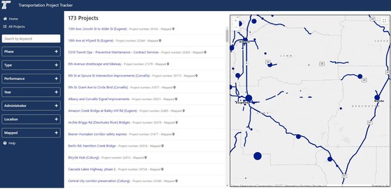
Click here for ODOT Project tracker map.

The map is designed to show information about the scope, schedule and budget of projects and studies, including projects in the Statewide Transportation Improvement Program known as the STIP, ODOT’s four-year capital improvement program. In just a few clicks, the user-friendly tool shows you where state transportation dollars are being spent. It also shows whether completed projects are on time and on budget.

Other features include:

  • Project snapshots with a brief description and summary of the project or study.
  • Search options, where you can zoom in to the map or using the search box.
  • Project clusters – project point locations are clustered on the map in high density areas to reduce the number of individual point locations displayed on the map and provide a cleaner user experience. The varying sizes of the clusters correlate to the number of locations in area.

View the ODOT Transportation Project Tracker at https://gis.odot.state.or.us/tpt/. Detailed information about the data displayed is available on the ODOT website.

Slide Slide Slide Slide Slide Slide Slide Slide Subscribe Contribute

Ads

Featured Video

Tillamook Weather

Tides

Tillamook County Pioneer Podcast Series

Tillamook Church Search

Cloverdale Baptist Church
Nestucca Valley Presbyterian
Tillamook Ecumenical Service

Archives

  • Home
  • EULA Privacy Policy
  • Contact
  • Opt-out preferences
  • Search...
Share on facebook
Facebook
Share on pinterest
Pinterest
Share on twitter
Twitter
Share on linkedin
Linkedin
Catherine

Recent Posts

  • Tillamook PUD Lineworker Program Scholarships Awarded

    July 5, 2025
  • TILLAMOOK COUNTY PUBLIC WORKS NOTICE: July 7th, 2025 ROAD WORK; July 8th, 2025 ROAD CLOSURE - Olsen Rd / Trask River Rd / 3rd St / Fairview Rd Intersection

    July 5, 2025
  • DECLARATION OF INDEPENDENCE - July 4, 1776; Video Reading from Tillamook Library's Maxwell Park - 249th Birthday of US July 4, 2025

    July 4, 2025
©2025 | Theme by SuperbThemes

Manage Cookie Consent
To provide the best experiences, we use technologies like cookies to store and/or access device information. Consenting to these technologies will allow us to process data such as browsing behavior or unique IDs on this site. Not consenting or withdrawing consent, may adversely affect certain features and functions.
Functional Always active
The technical storage or access is strictly necessary for the legitimate purpose of enabling the use of a specific service explicitly requested by the subscriber or user, or for the sole purpose of carrying out the transmission of a communication over an electronic communications network.
Preferences
The technical storage or access is necessary for the legitimate purpose of storing preferences that are not requested by the subscriber or user.
Statistics
The technical storage or access that is used exclusively for statistical purposes. The technical storage or access that is used exclusively for anonymous statistical purposes. Without a subpoena, voluntary compliance on the part of your Internet Service Provider, or additional records from a third party, information stored or retrieved for this purpose alone cannot usually be used to identify you.
Marketing
The technical storage or access is required to create user profiles to send advertising, or to track the user on a website or across several websites for similar marketing purposes.
Manage options Manage services Manage {vendor_count} vendors Read more about these purposes
View preferences
{title} {title} {title}