




Tillamook County Pioneer

News & People of Tillamook County. Every Day.

Menu
  • Home
  • Feature
    • Breaking News
    • Arts
    • Astrology
    • Business
    • Community
    • Employment
    • Event Stories
    • From the Pioneer
    • Government
    • Letters to the Editor
    • Non Profit News
    • Obituary
    • Public Safety
    • Podcast Interview Articles
    • Pioneer Pulse Podcast: Politics, Palette, and Planet – the Playlist
  • Guest Column
    • Perspectives
    • Don Backman Photos
    • Ardent Gourmet
    • Kitchen Maven
    • I’ve been thinking
    • Jim Heffernan
    • The Littoral Life
    • Neal Lemery
    • View From Here
    • Virginia Carrell Prowell
    • Words of Wisdom
    • Chuck McLaughlin – 1928 to 2025
  • Weather
  • Post Submission
  • Things to do
    • Calendar
    • Tillamook County Parks
    • Tillamook County Hikes
    • Whale Watching
    • Tillamook County Library
    • SOS Community Calendar
  • About
    • Contribute
    • Advertise
    • Subscribe
    • Opt-out preferences
  • Search...
Menu

MORE GORDON – EXTRA WEATHER UPDATE 9/24/26: First “Storm” of Season

Posted on September 24, 2026 by Editor

By Gordon McCraw, Meteorologist for the Tillamook County Pioneer

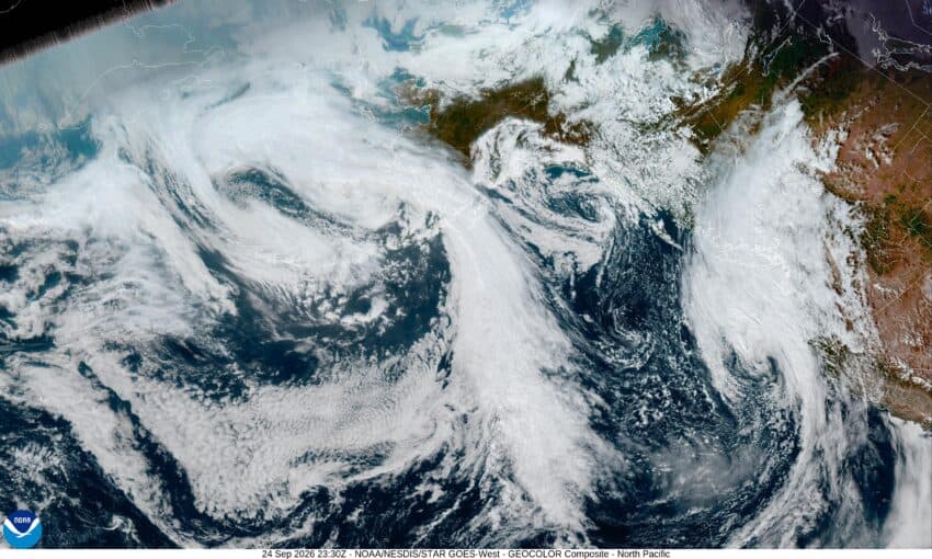
The first day of fall was Tuesday and now it appears Mother Nature wants to make it official. Today, we have a developing fall low pressure system moving in that will bring some soaking rain, gusty winds, and cooler temperatures into the area. As I write this at noon on Thursday, it looks like we have an increasing chance of rain starting this afternoon with rain likely by around 4pm today as the low pushes a front through. The winds will initially be southerly 5-10 later this afternoon, then later tonight increasing to 14-18 gusting to 30. As is usually the case, down at the beaches, tonight they are looking at southerly winds 20-25 gusting to 45. Yes, for the mariners, there is a Gale Warning in effect from 11pm tonight through 2pm Friday with seas increasing to 15-19’. This could also cause a Coastal Advisory for the high surf and the increased sneaker wave threat. As far as how much rain we can expect tonight, maybe between ¼ to ½”. Tonight, after the front pushes through, we are looking at showers that will persist into Friday. The low temperature tonight near 54.

We expect the shower activity will become more frequent tomorrow with some heavier showers possible as the air becomes more unstable, which means there is a slight chance of a thunderstorm or two also. The National Weather Service points out that given the possible low level shear this type system produces, they cannot rule out seeing a cold-core funnel cloud associated with a heavy rainshower or thunderstorm Friday. In addition to all this, the winds tomorrow are expected to be southerly 15-20, gusting to 30-35 with gust to 45 at the beaches and headlands. When you combine the movement of the stronger showers with the downburst outflow associated with the shower, there is a slight chance of seeing isolated gusts to 45-50 inland also. The high temperature tomorrow around 60. The activity eases later tomorrow afternoon then diminishes tomorrow night as the trough and low moves out of Oregon, the winds ease by sunset, the total rainfall tomorrow between ½ to 1”, dependent on how many showers move across your location.

So, know that with these winds, this early in the season, with the trees still with most of their leaves, it is possible to see a limb or two break off, which means some power outages are also possible. The rivers are all pretty low, so this rain will only make the fishermen happy, but flooding is not an issue unless the leaves block the drainage causing localized street flooding.

After all that fun on Friday, the weekend is looking partly to mostly sunny with highs in the low 60s, nighttime lows in the mid 40s.

The models say we see another trough for the start of next week that gives us a chance of rain by Tuesday, then a ridge of high pressure gives us fair, dry, and somewhat cooler temperatures for the middle of the week.

And there you have it folks. Stay safe and I’ll be back Monday unless something changes!

Please consider supporting the Pioneer with a contribution. Independent journalism stays alive on the Coast. Click here to contribute!

Ads

  • 14 days
Keep the News Free to Read

Featured Video

Tillamook Weather

Tides

Tillamook Church Search

Cloverdale Baptist Church
Nestucca Valley Presbyterian
Tillamook Ecumenical Service

Tillamook County Pioneer Podcast Series

Archives

  • Home
  • EULA Privacy Policy
  • Contact
  • Opt-out preferences
  • Search...
Share on facebook
Facebook
Share on pinterest
Pinterest
Share on twitter
Twitter
Share on linkedin
Linkedin
Catherine

Recent Posts

  • Manzanita Farmers Market - THIS IS IT - Final Friday 9/25/26! Closing at 6 ... FREE Ice Cream!

    September 24, 2026
  • MORE GORDON - EXTRA WEATHER UPDATE 9/24/26: First "Storm" of Season

    September 24, 2026
  • Festival of Well-Being Saturday October 3 & 4 at North County Recreation District

    September 24, 2026
©2026 Tillamook County Pioneer | Theme by SuperbThemes
Manage Cookie Consent
To provide the best experiences, we use technologies like cookies to store and/or access device information. Consenting to these technologies will allow us to process data such as browsing behavior or unique IDs on this site. Not consenting or withdrawing consent, may adversely affect certain features and functions.
Functional Always active
The technical storage or access is strictly necessary for the legitimate purpose of enabling the use of a specific service explicitly requested by the subscriber or user, or for the sole purpose of carrying out the transmission of a communication over an electronic communications network.
Preferences
The technical storage or access is necessary for the legitimate purpose of storing preferences that are not requested by the subscriber or user.
Statistics
The technical storage or access that is used exclusively for statistical purposes. The technical storage or access that is used exclusively for anonymous statistical purposes. Without a subpoena, voluntary compliance on the part of your Internet Service Provider, or additional records from a third party, information stored or retrieved for this purpose alone cannot usually be used to identify you.
Marketing
The technical storage or access is required to create user profiles to send advertising, or to track the user on a website or across several websites for similar marketing purposes.
  • Manage options
  • Manage services
  • Manage {vendor_count} vendors
  • Read more about these purposes
View preferences
  • {title}
  • {title}
  • {title}