Menu
  • Home
  • Feature
    • Breaking News
    • Arts
    • Astrology
    • Business
    • Community
    • Employment
    • Event Stories
    • From the Pioneer
    • Government
    • Letters to the Editor
    • Non Profit News
    • Obituary
    • Public Safety
    • Podcast Interview Articles
    • Pioneer Pulse Podcast: Politics, Palette, and Planet – the Playlist
  • Guest Column
    • Perspectives
    • Don Backman Photos
    • Ardent Gourmet
    • Kitchen Maven
    • I’ve been thinking
    • Jim Heffernan
    • The Littoral Life
    • Neal Lemery
    • View From Here
    • Virginia Carrell Prowell
    • Words of Wisdom
  • Weather
  • Post Submission
  • Things to do
    • Calendar
    • Tillamook County Parks
    • Tillamook County Hikes
    • Whale Watching
    • Tillamook County Library
    • SOS Community Calendar
  • About
    • Contribute
    • Advertise
    • Subscribe
    • Opt-out preferences
  • Search...
Menu

National Weather Service Portland Updated Briefing for Heavy Cascades Snow and Low Snow Levels through Monday

Posted on March 31, 2023March 31, 2023 by Editor

(3/31/23)

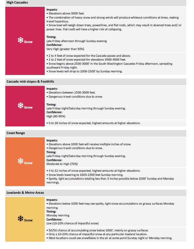
Good morning, this is an update to yesterday‘s briefing regarding very heavy snow that is expected for the Cascades this weekend. Some changes have been made to the forecast and warnings. Primary impacts will be for elevations 1500′ and above. Above 3000’, snow will likely be measured in feet this weekend. We have also included an outlook regarding the potential of low elevation snow.

KEY POINTS

  • Mountain snow begins late this afternoon or tonight depending on location, with impacts increasing overnight and continuing through this weekend.
  • Heaviest snow will be above 3500 to 4000 feet, where 2 to 4 feet of snow are expected.
  • Cascade passes are highly likely (over 90% confidence) to receive over a foot of snow this weekend.
  • Coast Range passes will be impacted with snow, with the greatest impacts coming during the cooler night and morning hours.
  • Less severe, but still impactful, accumulations are likely between 1000 to 2500 ft beginning tonight or Sat morning.
  • Impacts are expected to be minimal for elevations below 1000 feet, but there remains a 10-20% chance of 1 inch of snow for any given location.

CHANGES FROM PREVIOUS BRIEFING

  • Heavy snowfall is now expected for elevations above 1500 feet, impacting some foothill towns and the Coast Range passes.
  • Winter Weather Advisories have been upgraded to Winter Storm Warnings for the Cascade and Coast Range elevations above 1500 feet.
  • Risk levels have been elevated due to increasing confidence that well over a foot of snow will fall in the Cascades this weekend.
  • Risk and impact outlook extended through Monday to capture low elevation snow possibilities.
  • Section added for lowland and metro area snow potential.


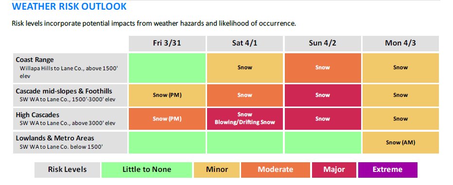
WEATHER RISK OUTLOOK

Risk levels incorporate potential impacts from weather hazards and likelihood of occurrence.


Slide Slide Slide Slide Slide Slide Slide Slide Subscribe Contribute

Ads

Featured Video

Tillamook Weather

Tides

Tillamook County Pioneer Podcast Series

Tillamook Church Search

Cloverdale Baptist Church
Nestucca Valley Presbyterian
Tillamook Ecumenical Service

Archives

  • Home
  • EULA Privacy Policy
  • Contact
  • Opt-out preferences
  • Search...
Share on facebook
Facebook
Share on pinterest
Pinterest
Share on twitter
Twitter
Share on linkedin
Linkedin
Catherine

Recent Posts

  • ROCKAWAY BEACH READIES FOR JULY 4TH FESTIVITIES - HONORS VOLUNTEER OF YEAR & PARADE GRAND MARSHAL

    June 30, 2025
  • NEWS UPDATE FROM STATE REPRESENTATIVE DAVID GOMBERG: It's a Session Wrap!

    June 30, 2025
  • GORDON'S WEEKLY WEATHER UPDATE 6/30/25: Back to Normal Summer Weather This Week - Fair, Dry & Mild; Holiday Weekend Weather Looks Good

    June 30, 2025
©2025 | Theme by SuperbThemes

Manage Cookie Consent
To provide the best experiences, we use technologies like cookies to store and/or access device information. Consenting to these technologies will allow us to process data such as browsing behavior or unique IDs on this site. Not consenting or withdrawing consent, may adversely affect certain features and functions.
Functional Always active
The technical storage or access is strictly necessary for the legitimate purpose of enabling the use of a specific service explicitly requested by the subscriber or user, or for the sole purpose of carrying out the transmission of a communication over an electronic communications network.
Preferences
The technical storage or access is necessary for the legitimate purpose of storing preferences that are not requested by the subscriber or user.
Statistics
The technical storage or access that is used exclusively for statistical purposes. The technical storage or access that is used exclusively for anonymous statistical purposes. Without a subpoena, voluntary compliance on the part of your Internet Service Provider, or additional records from a third party, information stored or retrieved for this purpose alone cannot usually be used to identify you.
Marketing
The technical storage or access is required to create user profiles to send advertising, or to track the user on a website or across several websites for similar marketing purposes.
Manage options Manage services Manage {vendor_count} vendors Read more about these purposes
View preferences
{title} {title} {title}