Menu
  • Home
  • Breaking News
  • Feature
    • Arts
    • Astrology
    • Business
    • Community
    • Employment
    • Event Stories
    • From the Pioneer
    • Government
    • Letters to the Editor
    • Non Profit News
    • Obituary
    • Public Safety
    • Podcast Interview Articles
    • Pioneer Pulse Podcast: Politics, Palette, and Planet – the Playlist
  • Weather
  • Guest Column
    • Perspectives
    • Don Backman Photos
    • Ardent Gourmet
    • Kitchen Maven
    • I’ve been thinking
    • Jim Heffernan
    • The Littoral Life
    • Neal Lemery
    • View From Here
    • Virginia Carrell Prowell
    • Words of Wisdom
  • Things to do
    • Calendar
    • Tillamook County Parks
    • Tillamook County Hikes
    • Whale Watching
    • Tillamook County Library
    • SOS Community Calendar
  • About
    • Contribute
    • Advertise
    • Subscribe
    • Opt-out preferences
  • Post Submission Test
  • Search...
Menu

SPECIAL WEEKEND EDITION – GORDON’S UPDATE: Winter Weather Outlook 23-24

Posted on September 30, 2023September 30, 2023 by Editor

By Meteorologist Gordon McCraw for the Tillamook County Pioneer
(Facebook – Gordon’s Weather Center)

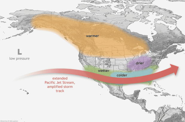
 Septenber 30, 2023 – Can you believe it is time once again for me to pull out my magic cyrstal ball to see what this year’s winter season has in store? As I say every year, one of the strongest influences on the U.S. seasonal climate, especially in the winter, is El Nino or La Nina conditions.  As a review, El Nino is the warm phase of the El Nino-Southern Oscillation (ENSO) climate pattern.  This means the water in the central and eastern equatorial Pacific is running warmer than average.  With these conditions, we generally see the Pacific Jet Stream move southward and spreads further east over the winter, leading to warmer and drier conditions for us in the Pacific Northwest.

I guess I can stop there because we are already seeing the indicators that those waters have become warmer  in that region:

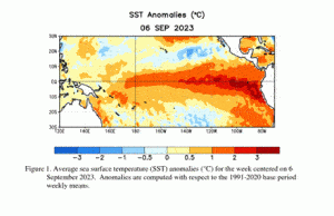
The Center says that during the last 4 weeks, the equatorial tempertures were above average across most of the Pacific.


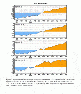
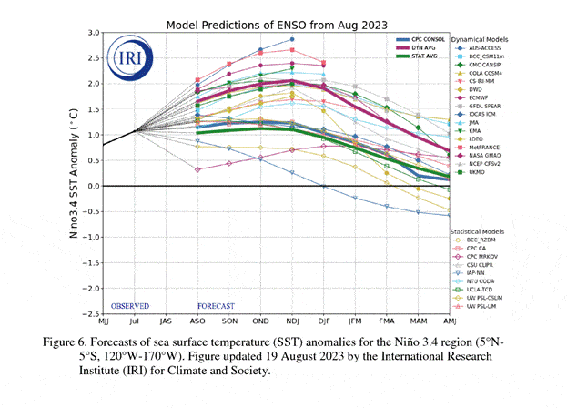
…and the Climate Prediction Center says, at present, there is a 95% chance of this persisting through the January-March 2024 time frame and a 71% chance that it peaks as a Strong El Nino this winter. The models below back this up, showing the Sea Surface Temperatures are forecasted to remain above the ENSO neutral line.

So, what does all this mean for us? Well, first, remember that seeing a strong El Nino DOES NOT necessarily mean strong El Nino conditions locally, it just means a stronger chance that El Nino impacts will occur…somewhere! The data is just an indicator of history.  The ENSO Blog offered a few reminders they have learned over the years:

  1. You CANNOT blame EVERYTHING on El Nino.
  2. No two El Ninos are alike, and the same can go for their impacts.
  3. And, just because a strong event is forecasted doen not necessarily means strong impacts. It instead means El Nino can increase the chances for certain types of extremes; we could see all the extremes, or none of the extremes, put them together and we have an average!

And here is the Climate Centers Outlooks.

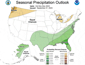
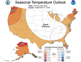
October-November-December


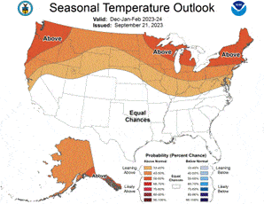
December-January-February


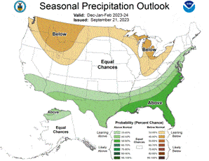
As you can see on the above Outlooks, and as suggested by the increasing El Nino, the Pacific Northwest has a 40-50% chance of seeing Below Normal Precipitation through December, then a 30-40% chance through March.  It also has a 50-60% chance of seeing above normal Temperatures for that entire period. Again, just like other forecasts, these are subject to chance in their next report, but you can see the trend.

And one more reminder, the Winter of 2007 was an El Nino period and was considered a light storm season, but there was that one storm in early December of 2007, remember the storm that was later named the “Great Coastal Gale of 2007?”  That was an El Nino year! I have said over and over, it can be a relatively inactive season, but if the one severe storm that year goes over your house, did you have an active or inactive year?


Featured Video

Slide Contribute SUBSCRIBE

Tillamook Weather

Tides

Tillamook County Pioneer Podcast Series

Tillamook Church Search

Cloverdale Baptist Church
Nestucca Valley Presbyterian
Tillamook Ecumenical Service

Archives

  • Home
  • EULA Privacy Policy
  • Contact
  • Opt-out preferences
  • Search...
Share on facebook
Facebook
Share on pinterest
Pinterest
Share on twitter
Twitter
Share on linkedin
Linkedin
Catherine

Recent Posts

  • MEMORIAL DAY SERVICES: Nehalem American Legion Cemetery; Rockaway Beach Wayside; Sunset Heights Memorial Gardens - Monday May 26th

    May 25, 2025
  • OREGON STATE POLICE: FATAL CRASH - HIGHWAY 26 - TILLAMOOK COUNTY, SATURDAY MAY 24

    May 25, 2025
  • United Paws Kitten of the Week:  Meet Poppet

    May 25, 2025
©2025 | Theme by SuperbThemes

Manage Cookie Consent
To provide the best experiences, we use technologies like cookies to store and/or access device information. Consenting to these technologies will allow us to process data such as browsing behavior or unique IDs on this site. Not consenting or withdrawing consent, may adversely affect certain features and functions.
Functional Always active
The technical storage or access is strictly necessary for the legitimate purpose of enabling the use of a specific service explicitly requested by the subscriber or user, or for the sole purpose of carrying out the transmission of a communication over an electronic communications network.
Preferences
The technical storage or access is necessary for the legitimate purpose of storing preferences that are not requested by the subscriber or user.
Statistics
The technical storage or access that is used exclusively for statistical purposes. The technical storage or access that is used exclusively for anonymous statistical purposes. Without a subpoena, voluntary compliance on the part of your Internet Service Provider, or additional records from a third party, information stored or retrieved for this purpose alone cannot usually be used to identify you.
Marketing
The technical storage or access is required to create user profiles to send advertising, or to track the user on a website or across several websites for similar marketing purposes.
Manage options Manage services Manage {vendor_count} vendors Read more about these purposes
View preferences
{title} {title} {title}