Menu
  • Home
  • Feature
    • Breaking News
    • Arts
    • Astrology
    • Business
    • Community
    • Employment
    • Event Stories
    • From the Pioneer
    • Government
    • Letters to the Editor
    • Non Profit News
    • Obituary
    • Public Safety
    • Podcast Interview Articles
    • Pioneer Pulse Podcast: Politics, Palette, and Planet – the Playlist
  • Guest Column
    • Perspectives
    • Don Backman Photos
    • Ardent Gourmet
    • Kitchen Maven
    • I’ve been thinking
    • Jim Heffernan
    • The Littoral Life
    • Neal Lemery
    • View From Here
    • Virginia Carrell Prowell
    • Words of Wisdom
  • Weather
  • Post Submission
  • Things to do
    • Calendar
    • Tillamook County Parks
    • Tillamook County Hikes
    • Whale Watching
    • Tillamook County Library
    • SOS Community Calendar
  • About
    • Contribute
    • Advertise
    • Subscribe
    • Opt-out preferences
  • Search...
Menu

TILLAMOOK COUNTY DAILY WEATHER BRIEFING: Gordon’s Update – 4/4/22

Posted on April 4, 2022 by Editor

By Gordon McCraw
Monday, April 4, 2022, 09:00am
Weather

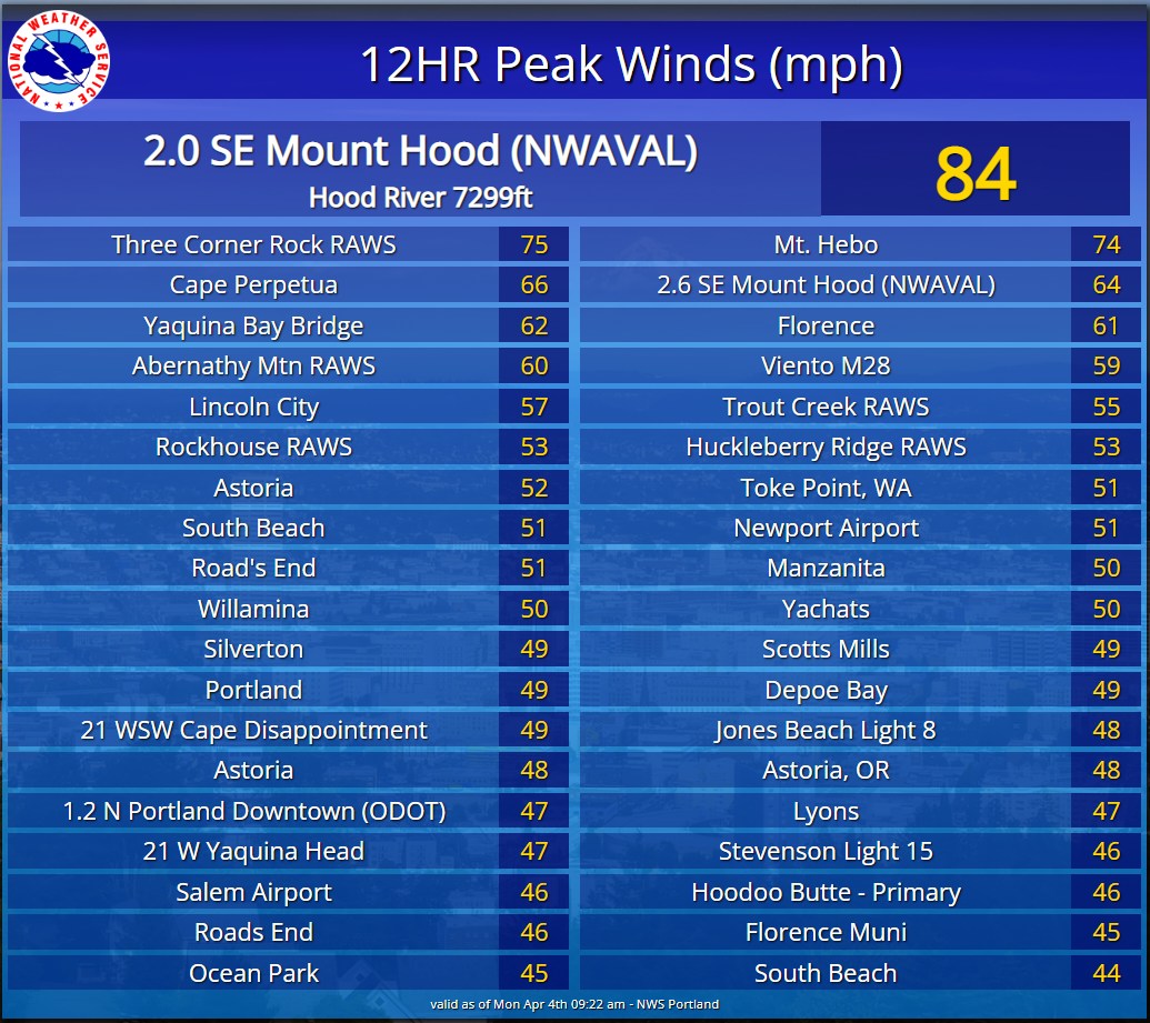
The front/atmospheric river brought plenty of rain and winds overnight. As far as rain, the area saw moderate, occasionally heavy rain that gave us between 1 ¼” to 1 ½” of rain while the Coast Range saw 2” to 2 ½”. This did cause the rivers to respond but fortunately, they were relatively low and while they did rise several feet, and continue to rise, the front has passed through, and the rain is easing so the rivers should all crest soon well below Action Stage. As far as winds, Tillamook Airport saw a max gust of 40, Astoria – 51, Pacific City – 41, and Garibaldi recorded a 67. There have been a few power outages associated with the high winds and the weather conditions offshore have generated high surf, so we continue with a High Surf Advisory until 11:00am tomorrow. We do still have a High Wind Warning until 11:00pm tonight. Sneaker Waves are also a hazard so use extreme caution while near the surf zone on the beaches, stay off of rocks, jetties, and beach logs.

So, the official weather picture looks like this, the front has pushed on thru moving south and east of the area and the associated low pressure area to the northwest is moving toward Vancouver Island. We can expect scattered showers to develop now behind the front as more unstable air moves in and with daytime heating, thunderstorms are possible this afternoon and some could be heavy with strong gusty winds and hail. The thunderstorm activity will continue tonight, still with some gusty winds, high temperatures today near 53, lows tonight near 40.

Tomorrow high pressure starts to build in, so the shower activity diminishes tomorrow morning and we slowly become mostly sunny, winds becoming westerly 10-15 gusting to 20, the afternoon high near 52 and the snow level around 2000’. With mostly clear skies tonight, along with calm winds, radiational cooling will let the lows drop to near 35. With all the moisture around, patchy morning fog and front is possible.

Wednesday and Thursday the ridge will give us mostly sunny skies and rising temperatures with the high Wednesday up to 62, Thursday we could see temperatures around 70. We can expect partly cloudy nighttime skies Wednesday night, lows near 43, then Thursday some clouds likely move in that night as the ridge shifts eastward, lows near 45.

Friday on the models get increasingly mixed. Some show the westerly flow returning and increasing that would push in the marine layer and cooler temperatures and a chance of light rain, the others show a dry and mild weekend. Unfortunately, the first scenario is starting to become the majority, so we are going with mostly cloudy skies Friday, Saturday and Sunday, high temperatures over the weekend in the low 50s, lows in the upper 30s with some scattered showers likely. The snow level will also likely fall to 2000’ Saturday and down to 1500’ Sunday.

Gordon McCraw

Featured Video

Ads

Slide Slide Slide Slide Slide Slide Slide Slide Subscribe Contribute

Tillamook Weather

Tides

Tillamook County Pioneer Podcast Series

Tillamook Church Search

Cloverdale Baptist Church
Nestucca Valley Presbyterian
Tillamook Ecumenical Service

Archives

  • Home
  • EULA Privacy Policy
  • Contact
  • Opt-out preferences
  • Search...
Share on facebook
Facebook
Share on pinterest
Pinterest
Share on twitter
Twitter
Share on linkedin
Linkedin
Catherine

Recent Posts

  • CITY OF MANZANITA - LET THE MOVE BEGIN! CITY HALL CLOSED TO WALK-IN SERVICES UNTIL MONDAY AUG. 4th; NEW CITY HALL OPENING AUG. 3

    June 23, 2025
  • NEWS UPDATE FROM STATE REPRESENTATIVE DAVID GOMBERG: Adjournment is Around the Corner

    June 23, 2025
  • NEHALEM BAY STATE PARK TO OPEN CAMPING RESERVATIONS FRIDAY, JUNE 27 FOR THIS SUMMER; PARTIAL OPENING OF CAMGROUND

    June 23, 2025
©2025 | Theme by SuperbThemes

Manage Cookie Consent
To provide the best experiences, we use technologies like cookies to store and/or access device information. Consenting to these technologies will allow us to process data such as browsing behavior or unique IDs on this site. Not consenting or withdrawing consent, may adversely affect certain features and functions.
Functional Always active
The technical storage or access is strictly necessary for the legitimate purpose of enabling the use of a specific service explicitly requested by the subscriber or user, or for the sole purpose of carrying out the transmission of a communication over an electronic communications network.
Preferences
The technical storage or access is necessary for the legitimate purpose of storing preferences that are not requested by the subscriber or user.
Statistics
The technical storage or access that is used exclusively for statistical purposes. The technical storage or access that is used exclusively for anonymous statistical purposes. Without a subpoena, voluntary compliance on the part of your Internet Service Provider, or additional records from a third party, information stored or retrieved for this purpose alone cannot usually be used to identify you.
Marketing
The technical storage or access is required to create user profiles to send advertising, or to track the user on a website or across several websites for similar marketing purposes.
Manage options Manage services Manage {vendor_count} vendors Read more about these purposes
View preferences
{title} {title} {title}