Menu
  • Home
  • Feature
    • Breaking News
    • Arts
    • Astrology
    • Business
    • Community
    • Employment
    • Event Stories
    • From the Pioneer
    • Government
    • Letters to the Editor
    • Non Profit News
    • Obituary
    • Public Safety
    • Podcast Interview Articles
    • Pioneer Pulse Podcast: Politics, Palette, and Planet – the Playlist
  • Guest Column
    • Perspectives
    • Don Backman Photos
    • Ardent Gourmet
    • Kitchen Maven
    • I’ve been thinking
    • Jim Heffernan
    • The Littoral Life
    • Neal Lemery
    • View From Here
    • Virginia Carrell Prowell
    • Words of Wisdom
  • Weather
  • Post Submission
  • Things to do
    • Calendar
    • Tillamook County Parks
    • Tillamook County Hikes
    • Whale Watching
    • Tillamook County Library
    • SOS Community Calendar
  • About
    • Contribute
    • Advertise
    • Subscribe
    • Opt-out preferences
  • Search...
Menu

TILLAMOOK COUNTY EMERGENCY MANAGEMENT: Gordon’s Update – 9/20/21 – Weather

Posted on September 20, 2021 by Editor

By Gordon McCraw, Tillamook County Emergency Manager
Monday, September 20, 2021, 10:30am
Weather

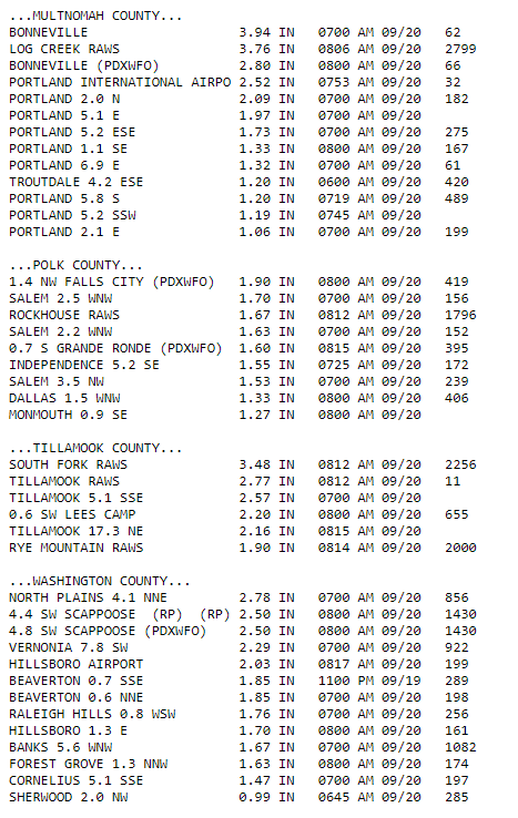
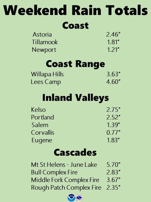
The front performed as forecasted for most, and we saw a decent amount of lightning from the system as well. Rainfall totals from the moderate, occasionally heavy rains ranged from around 2”-4” at the beaches to the Coast Range and 4”-6” in the Coast Range. Then the lightning show Saturday was pretty intense as well. Winds Friday night, in town, were 10-20 gusting got 40. The good news with all this, there were very few electrical outages and while the rivers did respond to the rain, the levels increased only between 1’ to 3’, and the rains minimized the fire dangers locally.

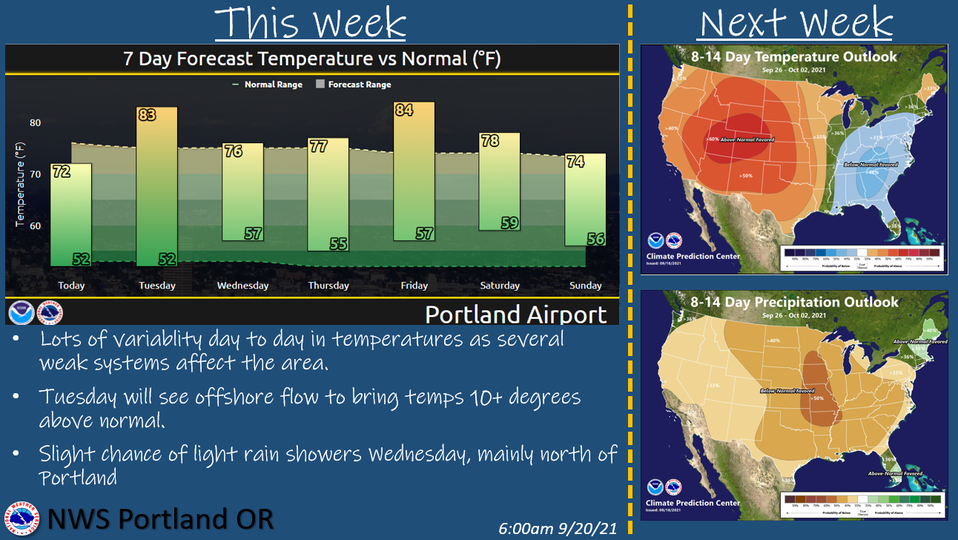
Today we have high pressure building in that will bring in the mostly sunny skies with afternoon winds becoming 5-10, today’s high near 67. With clear skies tonight and calm winds, the low drops to near 47.

The high will drift east tomorrow, moving over the top of us causing sunny skies, light winds and pushing the high up to near 73. Look for increasing clouds tomorrow night with the approach of a low pressure trough, some patchy fog is possible with the calm winds, lows near 46.

Wednesday the trough moves across the area in the afternoon that give us a few clouds, only a slight chance of a shower or two, and cools things back down so, only partly sunny skies, winds becoming northwesterly 5-10, highs near 67, back to part cloudy nighttime skies, light winds, the low near 44.

With another ridge dominating the area Thursday and Friday we can expect mostly sunny skies, high temperatures warming back into the lower 70s by Friday, partly cloudy nights, lows near 50. Saturday also starts out mostly sunny but it’s looking like another system will be sending in some increasing cloudiness starting that night which gives us a slight chance of showers into Sunday, the highs near 67, lows near 47.


Featured Video

Ads

Slide Slide Slide Slide Slide Slide Slide Slide Subscribe Contribute

Tillamook Weather

Tides

Tillamook County Pioneer Podcast Series

Tillamook Church Search

Cloverdale Baptist Church
Nestucca Valley Presbyterian
Tillamook Ecumenical Service

Archives

  • Home
  • EULA Privacy Policy
  • Contact
  • Opt-out preferences
  • Search...
Share on facebook
Facebook
Share on pinterest
Pinterest
Share on twitter
Twitter
Share on linkedin
Linkedin
Catherine

Recent Posts

  • CITY OF MANZANITA - LET THE MOVE BEGIN! CITY HALL CLOSED TO WALK-IN SERVICES UNTIL MONDAY AUG. 4th; NEW CITY HALL OPENING AUG. 3

    June 23, 2025
  • NEWS UPDATE FROM STATE REPRESENTATIVE DAVID GOMBERG: Adjournment is Around the Corner

    June 23, 2025
  • NEHALEM BAY STATE PARK TO OPEN CAMPING RESERVATIONS FRIDAY, JUNE 27 FOR THIS SUMMER; PARTIAL OPENING OF CAMGROUND

    June 23, 2025
©2025 | Theme by SuperbThemes

Manage Cookie Consent
To provide the best experiences, we use technologies like cookies to store and/or access device information. Consenting to these technologies will allow us to process data such as browsing behavior or unique IDs on this site. Not consenting or withdrawing consent, may adversely affect certain features and functions.
Functional Always active
The technical storage or access is strictly necessary for the legitimate purpose of enabling the use of a specific service explicitly requested by the subscriber or user, or for the sole purpose of carrying out the transmission of a communication over an electronic communications network.
Preferences
The technical storage or access is necessary for the legitimate purpose of storing preferences that are not requested by the subscriber or user.
Statistics
The technical storage or access that is used exclusively for statistical purposes. The technical storage or access that is used exclusively for anonymous statistical purposes. Without a subpoena, voluntary compliance on the part of your Internet Service Provider, or additional records from a third party, information stored or retrieved for this purpose alone cannot usually be used to identify you.
Marketing
The technical storage or access is required to create user profiles to send advertising, or to track the user on a website or across several websites for similar marketing purposes.
Manage options Manage services Manage {vendor_count} vendors Read more about these purposes
View preferences
{title} {title} {title}