(Northwest Weather Service – Portland – 3/10/23)
A swath of sub-tropical moisture is expected to bring a weak atmospheric river (AR) to northwest Oregon and southwest Washington early next week. This email focuses on the latest timing, forecast rainfall amounts, and impacts based on current model guidance for this upcoming AR.
General timeframe (moderate to high confidence):
- Sunday, March 12 – Tuesday March 14
- Period of heaviest precipitation: Sunday night – Monday
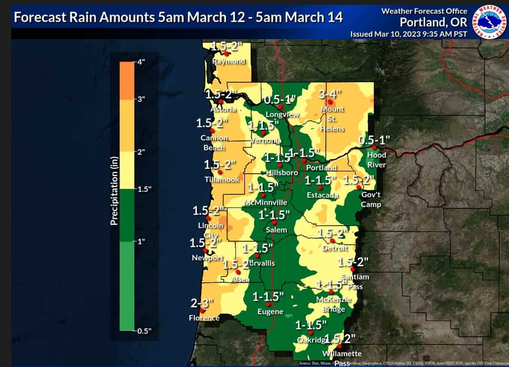
Forecast amounts based on latest model guidance (moderate confidence):
- The following are 48-hour forecast totals (Sun 5am – Tue 5am):
- Most likely scenario:
- Coast: 1.5-2 inches
- Coast Range/Cascades/Willapa Hills: 1.5-3 inches
- Interior lowlands (I-5 corridor from Lane to Cowlitz County): 1-1.5 inches
- Worst case scenario (10% chance):
- Coast: 2-3 inches
- Coast Range/Cascades/Willapa Hills: 3-5 inches
- Interior lowlands (I-5 corridor from Lane to Cowlitz County): 1.5-2 inches
Snow levels (high confidence):
- 3000-5000 feet
Impacts:
- Rivers/streams (high confidence):
- We are not concerned right now that rivers/streams will reach flood levels, even with the worst-case precipitation forecast
- This also considering snowpack melt
- We are not concerned right now that rivers/streams will reach flood levels, even with the worst-case precipitation forecast
- Burn scars (moderate confidence):
- We are not concerned right now for debris flow for burn scars. Model guidance does not support rainfall rates heavy enough to warrant these concerns.
- Still some uncertainty regarding hourly rain rates, but details should become more clear around 24 hours in advance of the event