Menu
  • Home
  • Breaking News
  • Feature
    • Arts
    • Astrology
    • Business
    • Community
    • Employment
    • Event Stories
    • From the Pioneer
    • Government
    • Letters to the Editor
    • Non Profit News
    • Obituary
    • Public Safety
    • Podcast Interview Articles
    • Pioneer Pulse Podcast: Politics, Palette, and Planet – the Playlist
  • Weather
  • Guest Column
    • Perspectives
    • Don Backman Photos
    • Ardent Gourmet
    • Kitchen Maven
    • I’ve been thinking
    • Jim Heffernan
    • The Littoral Life
    • Neal Lemery
    • View From Here
    • Virginia Carrell Prowell
    • Words of Wisdom
  • Things to do
    • Calendar
    • Tillamook County Parks
    • Tillamook County Hikes
    • Whale Watching
    • Tillamook County Library
    • SOS Community Calendar
  • About
    • Contribute
    • Advertise
    • Subscribe
    • Opt-out preferences
  • Post Submission Test
  • Search...
Menu

TILLAMOOK COUNTY WEATHER – Gordon’s Update Friday, June 11, 2021

Posted on June 11, 2021 by Editor

09:15am

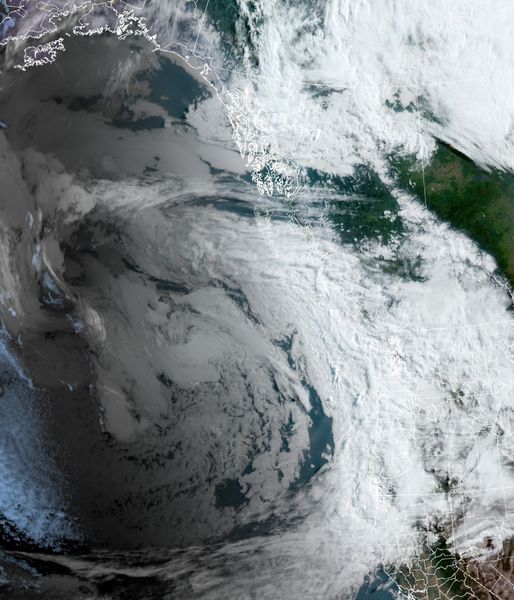
There is a large upper level low pressure area centered west of Vancouver Island that is not expected to move much over the next few days. Associated with this low is a front extending southeast to just off the coast of Oregon, then it extends southwestward back onto the Pacific. Embedded in all this are disturbances that will ride up along the front that enhances the rain threat at times. For now, it looks like the heavier rainfall amounts and higher winds will be well south of our area, to start anyway.

The front appears to go stationary along the coast later this afternoon as one of these disturbance moves northeastward on the front toward the area. By this time the front could be just to our east so areas in the valley and eastward could see the heaver rainfall in the region. It does appear that the lift from the Coast Range could squeeze out higher amounts there also, possibly between 1”-1.5” thru Saturday.

The disturbance will move north of the area Saturday, but we may see another disturbance riding the front into the area Saturday evening that would again enhance the rain potential for Saturday into Sunday, another inch or so. Though it is out of season so to speak, this qualifies, meteorologically, as an atmospheric river. The good news is flooding potential is pretty much non-existent and this rain is actually beneficial as it will delay the Fire Season some. There is some concern however, on the effects of this rain in those areas impacted by last season’s fires.

The front is still pretty much stalled over the region Monday when, for us, the rain transitions over to scattered showers. There is even a slight chance of thunderstorms east of the Coast Range Monday night into Tuesday. By Tuesday night the front gets a push that takes it well east of the area and things start to dry up as a ridge of high pressure builds in giving us mostly sunny skies Wednesday, the temperature then climbs up close to 70 with Thursday’s temperatures pushing close to the mid 70s. The long range models suggest we may stay mostly sunny and warm for much of next week.

Featured Video

Slide Contribute SUBSCRIBE

Tillamook Weather

Tides

Tillamook County Pioneer Podcast Series

Tillamook Church Search

Cloverdale Baptist Church
Nestucca Valley Presbyterian
Tillamook Ecumenical Service

Archives

  • Home
  • EULA Privacy Policy
  • Contact
  • Opt-out preferences
  • Search...
Share on facebook
Facebook
Share on pinterest
Pinterest
Share on twitter
Twitter
Share on linkedin
Linkedin
Catherine

Recent Posts

  • Tillamook Air Museum to Acquire Historic U.S. Coast Guard HU-25 Guardian

    May 24, 2025
  • Celebrate May at Camp Magruder with Two Special Events: Camp Magruder’s 80th Anniversary Celebration May 24th & Community Open House May 31st

    May 24, 2025
  • RESIDENTS STAND TOGETHER AGAINST CIRCUS CRUELTY IN TILLAMOOK, PROTEST OF JORDAN CIRCUS AT TILLAMOOK COUNTY FAIRGROUNDS TUESDAY MAY 27th

    May 24, 2025
©2025 | Theme by SuperbThemes

Manage Cookie Consent
To provide the best experiences, we use technologies like cookies to store and/or access device information. Consenting to these technologies will allow us to process data such as browsing behavior or unique IDs on this site. Not consenting or withdrawing consent, may adversely affect certain features and functions.
Functional Always active
The technical storage or access is strictly necessary for the legitimate purpose of enabling the use of a specific service explicitly requested by the subscriber or user, or for the sole purpose of carrying out the transmission of a communication over an electronic communications network.
Preferences
The technical storage or access is necessary for the legitimate purpose of storing preferences that are not requested by the subscriber or user.
Statistics
The technical storage or access that is used exclusively for statistical purposes. The technical storage or access that is used exclusively for anonymous statistical purposes. Without a subpoena, voluntary compliance on the part of your Internet Service Provider, or additional records from a third party, information stored or retrieved for this purpose alone cannot usually be used to identify you.
Marketing
The technical storage or access is required to create user profiles to send advertising, or to track the user on a website or across several websites for similar marketing purposes.
Manage options Manage services Manage {vendor_count} vendors Read more about these purposes
View preferences
{title} {title} {title}