Menu
  • Home
  • Breaking News
  • Feature
    • Arts
    • Astrology
    • Business
    • Community
    • Employment
    • Event Stories
    • From the Pioneer
    • Government
    • Letters to the Editor
    • Non Profit News
    • Obituary
    • Public Safety
    • Podcast Interview Articles
    • Pioneer Pulse Podcast: Politics, Palette, and Planet – the Playlist
  • Weather
  • Guest Column
    • Perspectives
    • Don Backman Photos
    • Ardent Gourmet
    • Kitchen Maven
    • I’ve been thinking
    • Jim Heffernan
    • The Littoral Life
    • Neal Lemery
    • View From Here
    • Virginia Carrell Prowell
    • Words of Wisdom
  • Things to do
    • Calendar
    • Tillamook County Parks
    • Tillamook County Hikes
    • Whale Watching
    • Tillamook County Library
    • SOS Community Calendar
  • About
    • Contribute
    • Advertise
    • Subscribe
    • Opt-out preferences
  • Post Submission Test
  • Search...
Menu

TILLAMOOK COUNTY EMERGENCY MANAGEMENT: Gordon’s Update – July 13th – Weather & Drought Conditions

Posted on July 13, 2021 by Editor

By Gordon McCraw, Tillamook County Emergency Manager

Tuesday, July 13, 2021, 11:30am

Weather

The marine layer is burning back quickly this morning leaving a mostly sunny day today.  Winds will again increase to westerly 10-15 gusting to 30, the high near 68. Tonight, we expect a weak disturbance to move across to our north that will enhance the marine layer tonight so look for cloudy skies tonight with a chance of patchy drizzle tonight after midnight, the winds diminish, lows near 54.

Tomorrow looks similar to today, cloudy with patchy drizzle to start that burns off leaving a mostly sunny afternoon, winds becoming northwesterly 5-10, highs near 65, then back comes the thicker marine layer tonight with another disturbance that likely gives us patchy drizzle again tomorrow night, diminishing winds, lows near 53.

We likely see cloudy skies with the patchy drizzle Thursday morning then again Friday morning, with a partly sunny afternoon, winds again northwesterly 5-10 in the afternoon, highs near 65, light drizzle is possible again Thursday night, some patchy fog is also possible in the early morning hours Friday, lows near 53.

The disturbances will be out of the area for the weekend leaving us with sunny skies Saturday Sunday on into Monday, highs near 69, mostly clear nights, lows near 52.


The Drought Continues

This month’s Drought Information Statement issued by the National Weather Service Portland on July 12th highlights that we are indeed experiencing moderate to extreme drought conditions in their forecast area, for Tillamook County, we are in the moderate category with several of our rivers ranking in the Lowest forecasted streamflow volume. The Nehalem River is at 38% of the historical record, the Trask is at 44%, their second lowest and the Wilson is at 45%, the lowest compared to historical records.

The Climate Prediction Center suggests that the period of July thru September will have a likelihood of having above average temperatures while we have an enhanced likelihood of below average temperatures.

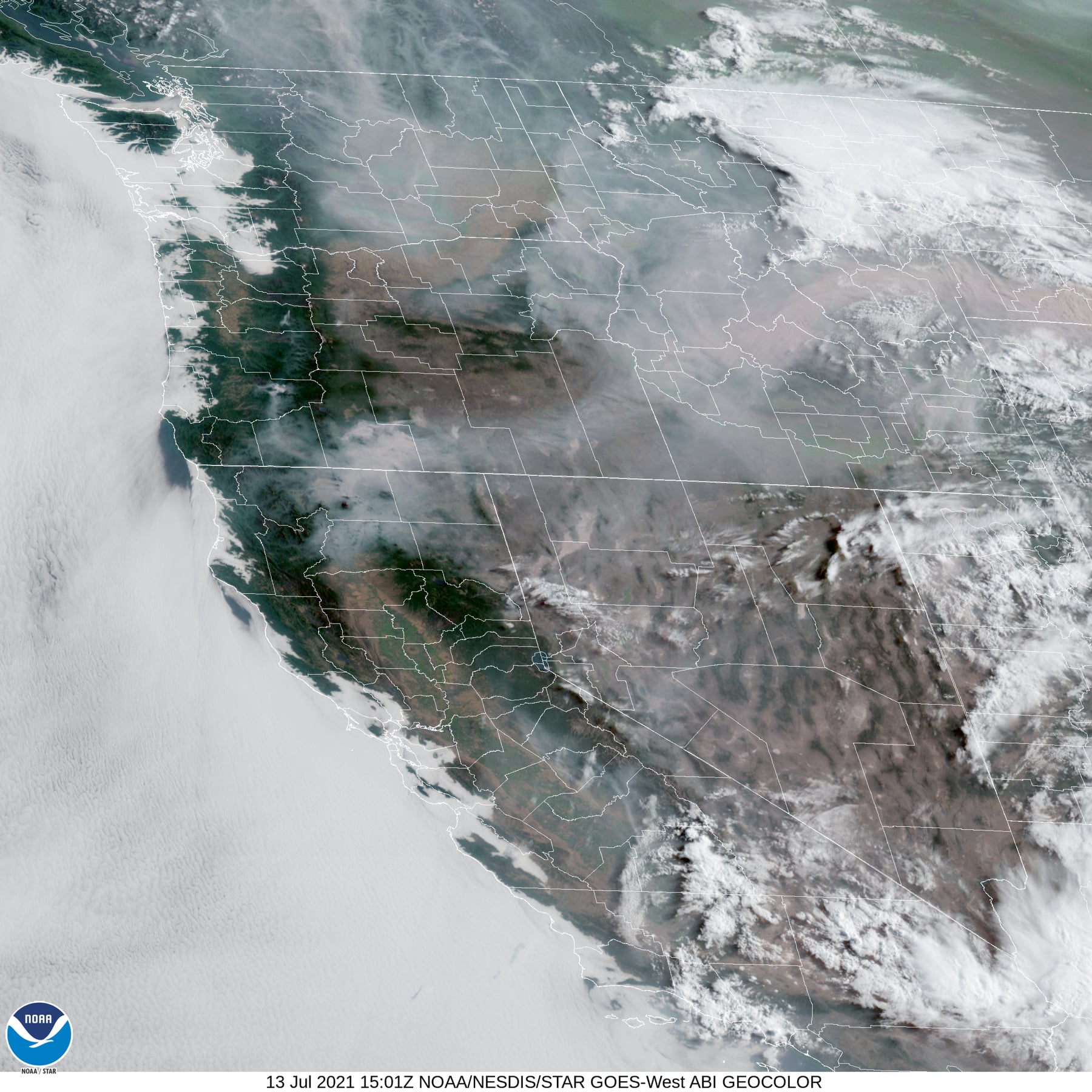
All this obviously can have a big impact on this year’s, already bad, fire season.  The state is currently tracking 23 fires, the largest of which remains the Bootleg Fire which is now over 200,000 acres.  The fires are already impacting Air Quality with Alerts in place near the larger fires.  We have been lucky here by having predominately a westerly flow over our area.

Featured Video

Slide Contribute SUBSCRIBE

Tillamook Weather

Tides

Tillamook County Pioneer Podcast Series

Tillamook Church Search

Cloverdale Baptist Church
Nestucca Valley Presbyterian
Tillamook Ecumenical Service

Archives

  • Home
  • EULA Privacy Policy
  • Contact
  • Opt-out preferences
  • Search...
Share on facebook
Facebook
Share on pinterest
Pinterest
Share on twitter
Twitter
Share on linkedin
Linkedin
Catherine

Recent Posts

  • Tillamook FFA Excels in State Career Development Events: Two Teams Headed to Nationals

    May 12, 2025
  • Tillamook Police Department Invites Community for Coffee with a Cop May 14th

    May 12, 2025
  • GORDON'S WEEKLY WEATHER UPDATE 5/12/25: Showery Pattern Continues Through Week

    May 12, 2025
©2025 | Theme by SuperbThemes

Manage Cookie Consent
To provide the best experiences, we use technologies like cookies to store and/or access device information. Consenting to these technologies will allow us to process data such as browsing behavior or unique IDs on this site. Not consenting or withdrawing consent, may adversely affect certain features and functions.
Functional Always active
The technical storage or access is strictly necessary for the legitimate purpose of enabling the use of a specific service explicitly requested by the subscriber or user, or for the sole purpose of carrying out the transmission of a communication over an electronic communications network.
Preferences
The technical storage or access is necessary for the legitimate purpose of storing preferences that are not requested by the subscriber or user.
Statistics
The technical storage or access that is used exclusively for statistical purposes. The technical storage or access that is used exclusively for anonymous statistical purposes. Without a subpoena, voluntary compliance on the part of your Internet Service Provider, or additional records from a third party, information stored or retrieved for this purpose alone cannot usually be used to identify you.
Marketing
The technical storage or access is required to create user profiles to send advertising, or to track the user on a website or across several websites for similar marketing purposes.
Manage options Manage services Manage {vendor_count} vendors Read more about these purposes
View preferences
{title} {title} {title}