Menu
  • Home
  • Feature
    • Breaking News
    • Arts
    • Astrology
    • Business
    • Community
    • Employment
    • Event Stories
    • From the Pioneer
    • Government
    • Letters to the Editor
    • Non Profit News
    • Obituary
    • Public Safety
    • Podcast Interview Articles
    • Pioneer Pulse Podcast: Politics, Palette, and Planet – the Playlist
  • Guest Column
    • Perspectives
    • Don Backman Photos
    • Ardent Gourmet
    • Kitchen Maven
    • I’ve been thinking
    • Jim Heffernan
    • The Littoral Life
    • Neal Lemery
    • View From Here
    • Virginia Carrell Prowell
    • Words of Wisdom
  • Weather
  • Post Submission
  • Things to do
    • Calendar
    • Tillamook County Parks
    • Tillamook County Hikes
    • Whale Watching
    • Tillamook County Library
    • SOS Community Calendar
  • About
    • Contribute
    • Advertise
    • Subscribe
    • Opt-out preferences
  • Search...
Menu

TILLAMOOK COUNTY DAILY WEATHER BRIEFING: Gordon’s Update

Posted on December 29, 2021February 2, 2023 by Editor

By Gordon McCraw, Tillamook County Emergency Manager
Wednesday, December 29, 2021, 10:00am
Weather

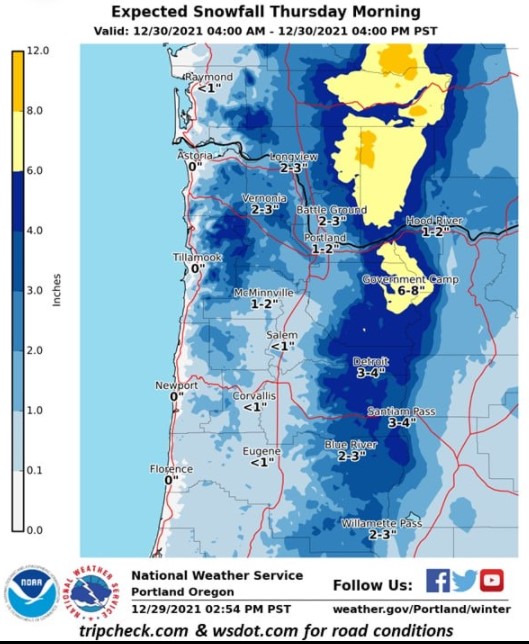
The temperature this morning was down around 30 degrees and reports of freezing fog means there were a few slick spots around the area. We are between systems today so we likely see some sunshine today. We also have some colder air dropping into the area so even with the sunshine we will only make it up to around 37 today. Winds today becoming easterly 4-8. We will see some clouds pushing in later this afternoon ahead of the next approaching system dropping southeastward towards the area. This will bring a chance of snow as the temperature drops to the upper 20s tonight, then a low level mix in the early morning hours with some southeasterly winds developing, the temperature will rise to 34.

A low level mix tomorrow morning turning to all rain by mid morning as things warm up some, winds becoming westerly 5-10, the afternoon high near 44, the snow level will rise to near 1400’ in the morning then up to 2300’ in the afternoon, the high near 44. A 50% chance of rain still tomorrow night, the snow level back down to around 1600’, lows near 32.

We see only a slight chance of rain from a system passing to our north on New Year’s Eve as a ridge of high pressure moves across our area, the snow level around 1500’ so the passes may see some flurries, calm winds, the high near 44.

For the weekend, we see another low pressure area dipping down from the Gulf of Alaska then become pretty much stationary over the weekend and into the start of next week, bringing rain and breezy conditions, and the rain could be heavy at times as the low pushes a couple of fronts across the area Sunday and again Monday, highs near 47, lows near 38. The snow level rests around 2900’, lowering to 1800’ the start of next week.

Featured Video

Ads

Slide Contribute SUBSCRIBE

Tillamook Weather

Tides

Tillamook County Pioneer Podcast Series

Tillamook Church Search

Cloverdale Baptist Church
Nestucca Valley Presbyterian
Tillamook Ecumenical Service

Archives

  • Home
  • EULA Privacy Policy
  • Contact
  • Opt-out preferences
  • Search...
Share on facebook
Facebook
Share on pinterest
Pinterest
Share on twitter
Twitter
Share on linkedin
Linkedin
Catherine

Recent Posts

  • Noland Arbaugh’s Neuralink Journey Unveiled

    June 21, 2025
  • WORDS OF WISDOM: Thinking About Fathers’ Day

    June 21, 2025
  • Nestucca High School heroes showed courage, compassion, and wisdom when it mattered most; Their quick action save Coach's life

    June 21, 2025
©2025 | Theme by SuperbThemes

Manage Cookie Consent
To provide the best experiences, we use technologies like cookies to store and/or access device information. Consenting to these technologies will allow us to process data such as browsing behavior or unique IDs on this site. Not consenting or withdrawing consent, may adversely affect certain features and functions.
Functional Always active
The technical storage or access is strictly necessary for the legitimate purpose of enabling the use of a specific service explicitly requested by the subscriber or user, or for the sole purpose of carrying out the transmission of a communication over an electronic communications network.
Preferences
The technical storage or access is necessary for the legitimate purpose of storing preferences that are not requested by the subscriber or user.
Statistics
The technical storage or access that is used exclusively for statistical purposes. The technical storage or access that is used exclusively for anonymous statistical purposes. Without a subpoena, voluntary compliance on the part of your Internet Service Provider, or additional records from a third party, information stored or retrieved for this purpose alone cannot usually be used to identify you.
Marketing
The technical storage or access is required to create user profiles to send advertising, or to track the user on a website or across several websites for similar marketing purposes.
Manage options Manage services Manage {vendor_count} vendors Read more about these purposes
View preferences
{title} {title} {title}