Menu
  • Home
  • Breaking News
  • Feature
    • Arts
    • Astrology
    • Business
    • Community
    • Employment
    • Event Stories
    • From the Pioneer
    • Government
    • Letters to the Editor
    • Non Profit News
    • Obituary
    • Public Safety
    • Podcast Interview Articles
    • Pioneer Pulse Podcast: Politics, Palette, and Planet – the Playlist
  • Weather
  • Guest Column
    • Perspectives
    • Don Backman Photos
    • Ardent Gourmet
    • Kitchen Maven
    • I’ve been thinking
    • Jim Heffernan
    • The Littoral Life
    • Neal Lemery
    • View From Here
    • Virginia Carrell Prowell
    • Words of Wisdom
  • Things to do
    • Calendar
    • Tillamook County Parks
    • Tillamook County Hikes
    • Whale Watching
    • Tillamook County Library
    • SOS Community Calendar
  • About
    • Contribute
    • Advertise
    • Subscribe
    • Opt-out preferences
  • Post Submission Test
  • Search...
Menu

TILLAMOOK COUNTY DAILY WEATHER BRIEFING: Gordon’s Weather Update – Sun. 2/27/22

Posted on February 27, 2022February 2, 2023 by Editor

By Gordon McCraw, for Tillamook County Emergency Management
Sunday, February 27, 2022, 10:30pm

The Tillamook area continues to see periods of rain, some heavy, as a front is stalled over the areas in a southwesterly flow, which is setting up as an atmospheric river event. You may have also noticed we are under the warm sector with overnight temperatures only falling into the mid 40s so the snow level is well above the Coast Range mountains. We have also seen some gusty winds early this morning with a peak gust at the airport near 35 with peak gusts along the beaches around 45.

So, the winds and rain will ease a bit today with southerly winds becoming 8-12 gusting to 20, the high near 53. We see more rain tonight with the winds becoming southeasterly 10-15 gusting to 30 with gusts at the beaches possibly up to 40-45, the temperatures continuing to rise to near 55, and we see another ¾” – 1” of additional rain into early tomorrow morning.
Tomorrow we see more rain, and it could be heavy at times with breezy southerly winds 20-30 gusting to 40 with gusts at the beaches possibly up to 55-65, the temperature still hovering up near the mid 50s, and we can expect another 1-2” of rain. The rain, heavy at times continues tomorrow night, still with some strong gusty winds, lows near 47, and another 1-2” of rain.

Tuesday the front will finally start to ease after loosing a lot of its moisture feed and then we watch for updates on the next system expected later next week.

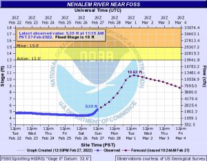
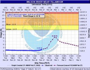
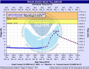
With all the rain and winds forecasted, the National Weather Service Portland has issued a Flood Watch for northwestern Oregon for the expected 2-5” of rain over Monday and Tuesday. They have also issued a High Wind Warning from 10PM this evening thru 4PM Monday for southerly winds 25-35 gusting to 45 in town, gusts to 60 at the beaches and headlands. While we are expecting heavy precipitation over the next few days, below you see that while the rivers do see a significant increase in flow rates, no flooding is forecasted. This should still be monitored for any changes.

Featured Video

Slide Contribute SUBSCRIBE

Tillamook Weather

Tides

Tillamook County Pioneer Podcast Series

Tillamook Church Search

Cloverdale Baptist Church
Nestucca Valley Presbyterian
Tillamook Ecumenical Service

Archives

  • Home
  • EULA Privacy Policy
  • Contact
  • Opt-out preferences
  • Search...
Share on facebook
Facebook
Share on pinterest
Pinterest
Share on twitter
Twitter
Share on linkedin
Linkedin
Catherine

Recent Posts

  • BRAVER ANGELS: Oregon Rural Urban Project Town Hall at Tillamook Library May 17th from 1 to 3pm

    May 11, 2025
  • Manzanita Citizen of the Year Nominations Open

    May 11, 2025
  • Support for Christy Kay for NCRD Board

    May 11, 2025
©2025 | Theme by SuperbThemes

Manage Cookie Consent
To provide the best experiences, we use technologies like cookies to store and/or access device information. Consenting to these technologies will allow us to process data such as browsing behavior or unique IDs on this site. Not consenting or withdrawing consent, may adversely affect certain features and functions.
Functional Always active
The technical storage or access is strictly necessary for the legitimate purpose of enabling the use of a specific service explicitly requested by the subscriber or user, or for the sole purpose of carrying out the transmission of a communication over an electronic communications network.
Preferences
The technical storage or access is necessary for the legitimate purpose of storing preferences that are not requested by the subscriber or user.
Statistics
The technical storage or access that is used exclusively for statistical purposes. The technical storage or access that is used exclusively for anonymous statistical purposes. Without a subpoena, voluntary compliance on the part of your Internet Service Provider, or additional records from a third party, information stored or retrieved for this purpose alone cannot usually be used to identify you.
Marketing
The technical storage or access is required to create user profiles to send advertising, or to track the user on a website or across several websites for similar marketing purposes.
Manage options Manage services Manage {vendor_count} vendors Read more about these purposes
View preferences
{title} {title} {title}