Menu
  • Home
  • Feature
    • Breaking News
    • Arts
    • Astrology
    • Business
    • Community
    • Employment
    • Event Stories
    • From the Pioneer
    • Government
    • Letters to the Editor
    • Non Profit News
    • Obituary
    • Public Safety
    • Podcast Interview Articles
    • Pioneer Pulse Podcast: Politics, Palette, and Planet – the Playlist
  • Guest Column
    • Perspectives
    • Don Backman Photos
    • Ardent Gourmet
    • Kitchen Maven
    • I’ve been thinking
    • Jim Heffernan
    • The Littoral Life
    • Neal Lemery
    • View From Here
    • Virginia Carrell Prowell
    • Words of Wisdom
  • Weather
  • Post Submission
  • Things to do
    • Calendar
    • Tillamook County Parks
    • Tillamook County Hikes
    • Whale Watching
    • Tillamook County Library
    • SOS Community Calendar
  • About
    • Contribute
    • Advertise
    • Subscribe
    • Opt-out preferences
  • Search...
Menu

TILLAMOOK COUNTY DAILY WEATHER BRIEFING: Gordon’s Update – 3/9/22

Posted on March 9, 2022 by Editor

By Gordon McCraw
Wednesday, March 9, 2022, 09:30am

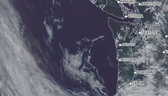
Well, looking at the satellite picture shows a mess in the Pacific headed this way. Today, for us, we have a disturbance moving thru that is causing some spotty light rain and drizzle. The precipitation comes to an end later today as high pressure starts to build in this afternoon and starts to clear things up giving us mostly sunny skies this afternoon. Winds today becoming northerly 8-12 gusting to 20, highs near 52. With mostly clear skies tonight and light winds, radiational cooling will allow the lows to drop into the upper 20s.

A nice day returns tomorrow with the ridge of high pressure bringing mostly sunny skies, winds becoming westerly 5-10, highs near 52, some clouds move in tomorrow night with light winds, the low near 37. The dry weather continues Friday with partly sunny skies, but the ridge will have started shifting to the east as a southwesterly flow develops, winds southwesterly 5-10, highs near 56.

The more moist and warmer southwesterly flow will be the result of a strong Jetstream setting up over the region which opens us up to fronts and disturbances that ride the southwesterly flow that brings rain up thru our area. The rain starts late Friday night or early Saturday morning, lows near 40.

So, the weekend looks wet and breezy with a front moving thru Saturday into Sunday highs near 53, lows near 44. Another wetter front approaches Sunday night bringing another round of rain that will be heavy at times, with breezy southerly winds also, especially along the beaches, and this persists thru Monday. Our hopes are that the systems will move thru fast enough to keep hydrological concerns low but as we have learned in the past, things can change so this is something we need to watch this weekend.

Light to moderate rain likely continues Monday and Tuesday, highs remain up around 50 or up into the low 50s, lows in the low to mid 40s. If river flooding were to become an issue, this is when it would likely affect the region.

Featured Video

Ads

Slide Slide Slide Slide Slide Slide Slide Slide Subscribe Contribute

Tillamook Weather

Tides

Tillamook County Pioneer Podcast Series

Tillamook Church Search

Cloverdale Baptist Church
Nestucca Valley Presbyterian
Tillamook Ecumenical Service

Archives

  • Home
  • EULA Privacy Policy
  • Contact
  • Opt-out preferences
  • Search...
Share on facebook
Facebook
Share on pinterest
Pinterest
Share on twitter
Twitter
Share on linkedin
Linkedin
Catherine

Recent Posts

  • CITY OF MANZANITA - LET THE MOVE BEGIN! CITY HALL CLOSED TO WALK-IN SERVICES UNTIL MONDAY AUG. 4th; NEW CITY HALL OPENING AUG. 3

    June 23, 2025
  • NEWS UPDATE FROM STATE REPRESENTATIVE DAVID GOMBERG: Adjournment is Around the Corner

    June 23, 2025
  • NEHALEM BAY STATE PARK TO OPEN CAMPING RESERVATIONS FRIDAY, JUNE 27 FOR THIS SUMMER; PARTIAL OPENING OF CAMGROUND

    June 23, 2025
©2025 | Theme by SuperbThemes

Manage Cookie Consent
To provide the best experiences, we use technologies like cookies to store and/or access device information. Consenting to these technologies will allow us to process data such as browsing behavior or unique IDs on this site. Not consenting or withdrawing consent, may adversely affect certain features and functions.
Functional Always active
The technical storage or access is strictly necessary for the legitimate purpose of enabling the use of a specific service explicitly requested by the subscriber or user, or for the sole purpose of carrying out the transmission of a communication over an electronic communications network.
Preferences
The technical storage or access is necessary for the legitimate purpose of storing preferences that are not requested by the subscriber or user.
Statistics
The technical storage or access that is used exclusively for statistical purposes. The technical storage or access that is used exclusively for anonymous statistical purposes. Without a subpoena, voluntary compliance on the part of your Internet Service Provider, or additional records from a third party, information stored or retrieved for this purpose alone cannot usually be used to identify you.
Marketing
The technical storage or access is required to create user profiles to send advertising, or to track the user on a website or across several websites for similar marketing purposes.
Manage options Manage services Manage {vendor_count} vendors Read more about these purposes
View preferences
{title} {title} {title}