Menu
  • Home
  • Feature
    • Breaking News
    • Arts
    • Astrology
    • Business
    • Community
    • Employment
    • Event Stories
    • From the Pioneer
    • Government
    • Letters to the Editor
    • Non Profit News
    • Obituary
    • Public Safety
    • Podcast Interview Articles
    • Pioneer Pulse Podcast: Politics, Palette, and Planet – the Playlist
  • Guest Column
    • Perspectives
    • Don Backman Photos
    • Ardent Gourmet
    • Kitchen Maven
    • I’ve been thinking
    • Jim Heffernan
    • The Littoral Life
    • Neal Lemery
    • View From Here
    • Virginia Carrell Prowell
    • Words of Wisdom
  • Weather
  • Post Submission
  • Things to do
    • Calendar
    • Tillamook County Parks
    • Tillamook County Hikes
    • Whale Watching
    • Tillamook County Library
    • SOS Community Calendar
  • About
    • Contribute
    • Advertise
    • Subscribe
    • Opt-out preferences
  • Search...
Menu

GORDON’S UPDATE: Weather 1/13/23 – Rain through the weekend; Pattern continues next week

Posted on January 13, 2023 by Editor

By Gordon McCraw, Meteorologist for the Tillamook County Pioneer
Friday, January 13, 2023
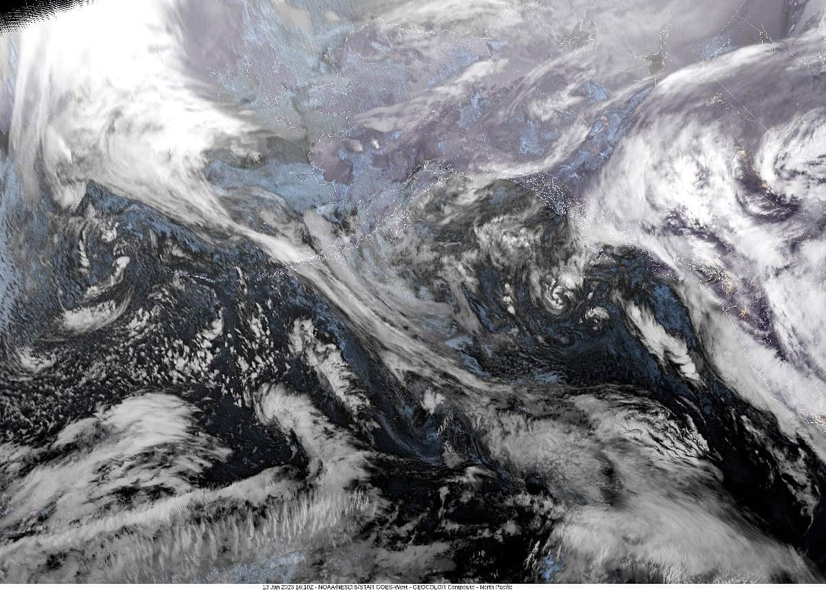
A trough of low pressure sits off the coast as the weak atmospheric river rests from California up thru Oregon, Washington on into Canada with the associated southerly flow pushing up the moisture giving us periods of drizzle and light rain. A quick look at the rainfall totals shows we have gotten less than 3” of rain over the three-day period which keeps our flooding concerns low. With all the activity in the Pacific, I would suggest the sneaker wave hazards along the beaches are still elevated.
So, the trough inched inland today, giving us more rain that persists tonight, winds southeasterly 5-10, tonight’s low near 47.

This weekend the pattern returns to a more zonal one in the Pacific, meaning the jet stream will again be pointed at California, and we will again see the low pressure areas developing and riding in the flow, intensifying but then slowing off the coast of California, and weakening before turning northward and skirting the coast to our west. This means the forecast will return to what we have seen for most of this and last week, cloudy to mostly cloudy with periods of mainly light rain, and occasionally breezy. Officially, Saturday’s forecast is, rainy with east winds 8-12, highs near 55, lows near 44. Sunday, we see morning rain from a front that pushes thru as the parent low moves up the coast, then some afternoon rainshowers with a slight chance of thunderstorms, winds southerly 10-15 gusting to 25, possibly gusting to 40-45 at the beaches, highs near 50, the winds ease Sunday night along with the thunderstorm threat after around midnight, lows near 40.

The pattern appears locked in place again for next week, so, more clouds with periods of rain and occasionally breezy as these lows move up the coast to our west. There is a glimmer of hope though, some models are suggesting a ridge of high pressure may build in towards the end of next week. That would give us some drying days for a change, maybe even some sunshine. Until then, cloudy, and rainy with highs around 50 and lows near 40 is the forecast. The snow level does appear to drop to around 2500-3000’ with a front midweek.

Slide Slide Slide Slide Slide Slide Slide Slide Subscribe Contribute

Ads

Featured Video

Tillamook Weather

Tides

Tillamook County Pioneer Podcast Series

Tillamook Church Search

Cloverdale Baptist Church
Nestucca Valley Presbyterian
Tillamook Ecumenical Service

Archives

  • Home
  • EULA Privacy Policy
  • Contact
  • Opt-out preferences
  • Search...
Share on facebook
Facebook
Share on pinterest
Pinterest
Share on twitter
Twitter
Share on linkedin
Linkedin
Catherine

Recent Posts

  • ROCKAWAY BEACH READIES FOR JULY 4TH FESTIVITIES - HONORS VOLUNTEER OF YEAR & PARADE GRAND MARSHAL

    June 30, 2025
  • NEWS UPDATE FROM STATE REPRESENTATIVE DAVID GOMBERG: It's a Session Wrap!

    June 30, 2025
  • GORDON'S WEEKLY WEATHER UPDATE 6/30/25: Back to Normal Summer Weather This Week - Fair, Dry & Mild; Holiday Weekend Weather Looks Good

    June 30, 2025
©2025 | Theme by SuperbThemes

Manage Cookie Consent
To provide the best experiences, we use technologies like cookies to store and/or access device information. Consenting to these technologies will allow us to process data such as browsing behavior or unique IDs on this site. Not consenting or withdrawing consent, may adversely affect certain features and functions.
Functional Always active
The technical storage or access is strictly necessary for the legitimate purpose of enabling the use of a specific service explicitly requested by the subscriber or user, or for the sole purpose of carrying out the transmission of a communication over an electronic communications network.
Preferences
The technical storage or access is necessary for the legitimate purpose of storing preferences that are not requested by the subscriber or user.
Statistics
The technical storage or access that is used exclusively for statistical purposes. The technical storage or access that is used exclusively for anonymous statistical purposes. Without a subpoena, voluntary compliance on the part of your Internet Service Provider, or additional records from a third party, information stored or retrieved for this purpose alone cannot usually be used to identify you.
Marketing
The technical storage or access is required to create user profiles to send advertising, or to track the user on a website or across several websites for similar marketing purposes.
Manage options Manage services Manage {vendor_count} vendors Read more about these purposes
View preferences
{title} {title} {title}