Menu
  • Home
  • Breaking News
  • Feature
    • Arts
    • Astrology
    • Business
    • Community
    • Employment
    • Event Stories
    • From the Pioneer
    • Government
    • Letters to the Editor
    • Non Profit News
    • Obituary
    • Public Safety
    • Podcast Interview Articles
    • Pioneer Pulse Podcast: Politics, Palette, and Planet – the Playlist
  • Weather
  • Guest Column
    • Perspectives
    • Don Backman Photos
    • Ardent Gourmet
    • Kitchen Maven
    • I’ve been thinking
    • Jim Heffernan
    • The Littoral Life
    • Neal Lemery
    • View From Here
    • Virginia Carrell Prowell
    • Words of Wisdom
  • Things to do
    • Calendar
    • Tillamook County Parks
    • Tillamook County Hikes
    • Whale Watching
    • Tillamook County Library
    • SOS Community Calendar
  • About
    • Contribute
    • Advertise
    • Subscribe
    • Opt-out preferences
  • Post Submission Test
  • Search...
Menu

GORDON’S UPDATE: Weather 3/9/23 – Rainy & breezy continues; Spring Ahead on Sunday 3/12/23

Posted on March 9, 2023 by Editor

By Gordon McCraw, Meteorologist for the Tillamook County Pioneer
Thursday, March 9, 2023

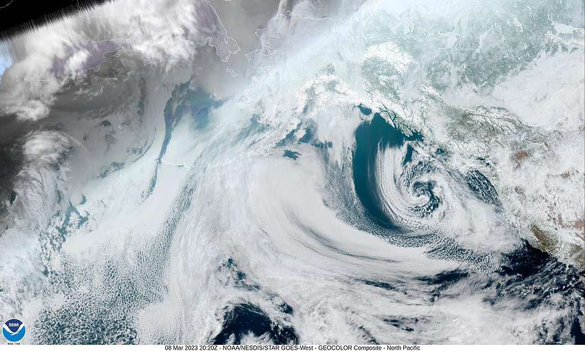
Today we are watching the low pressure area west of our area and the moisture that is wrapping around the east side of it that is affecting the coast. The low is also giving us increased winds across the region. To the south, northern California is dealing with more rain impacts from an “atmospheric river” pushing in.

This evening’s forecast is for continued rain with easterly winds this evening becoming southerly later tonight 14-18 gusting to 30. The snow level, which had climbed during the day, will again fall to around 1400’ after midnight so the summit could see more snow after midnight. Tonight’s low temperature near 35.

Tomorrow the low starts to lift northward then northeastward into Washington, and with an associated trough off our coast, tomorrow still looks rainy, winds westerly 8-12 gusting to 18, highs near 47, and the snow level lifts to near 2000’ in the afternoon. The rain starts to ease tomorrow night as the low continues inland but some lighter rain is still likely, winds southerly 5-10, lows near 37. With the southerly flow the snow level climbs to near 2200’ overnight.

Saturday still looks rainy though it could still be on the lighter side under mostly cloudy skies, winds still southerly 5-10, highs near 50, the snow level up near 2300’. This milder break is short though as the models continue to show another low pressure area developing further to the northwest than the previous one, so a developing atmospheric river will also be further north, so Sunday looks rainy and with the southwesterly flow and the warmer rain, highs climb to near 51, lows near 42. It does look like the heavier moisture areas will be in southern Oregon and north of the area in Washington into Monday when we see increased winds also. As I always say though, this can change before game time so stay tuned. Currently the river forecasts show increasing flow rates, but none are forecasting any flooding (at this time).

After this the associated front pushes thru and we are left with patchy rain Tuesday, the high near 49, lows near 38 with more rain likely Wednesday.

Another reminder, with all this weather fun, don’t forget, Sunday is “Time-Change” day where we lose an hour of sleep. Remember to spring-forward and set your clocks ahead an hour at 2AM, or, if you are like me, change them as you are headed to bed Saturday night!

Featured Video

Slide Contribute SUBSCRIBE

Tillamook Weather

Tides

Tillamook County Pioneer Podcast Series

Tillamook Church Search

Cloverdale Baptist Church
Nestucca Valley Presbyterian
Tillamook Ecumenical Service

Archives

  • Home
  • EULA Privacy Policy
  • Contact
  • Opt-out preferences
  • Search...
Share on facebook
Facebook
Share on pinterest
Pinterest
Share on twitter
Twitter
Share on linkedin
Linkedin
Catherine

Recent Posts

  • Tillamook FFA Excels in State Career Development Events: Two Teams Headed to Nationals

    May 12, 2025
  • Tillamook Police Department Invites Community for Coffee with a Cop May 14th

    May 12, 2025
  • GORDON'S WEEKLY WEATHER UPDATE 5/12/25: Showery Pattern Continues Through Week

    May 12, 2025
©2025 | Theme by SuperbThemes

Manage Cookie Consent
To provide the best experiences, we use technologies like cookies to store and/or access device information. Consenting to these technologies will allow us to process data such as browsing behavior or unique IDs on this site. Not consenting or withdrawing consent, may adversely affect certain features and functions.
Functional Always active
The technical storage or access is strictly necessary for the legitimate purpose of enabling the use of a specific service explicitly requested by the subscriber or user, or for the sole purpose of carrying out the transmission of a communication over an electronic communications network.
Preferences
The technical storage or access is necessary for the legitimate purpose of storing preferences that are not requested by the subscriber or user.
Statistics
The technical storage or access that is used exclusively for statistical purposes. The technical storage or access that is used exclusively for anonymous statistical purposes. Without a subpoena, voluntary compliance on the part of your Internet Service Provider, or additional records from a third party, information stored or retrieved for this purpose alone cannot usually be used to identify you.
Marketing
The technical storage or access is required to create user profiles to send advertising, or to track the user on a website or across several websites for similar marketing purposes.
Manage options Manage services Manage {vendor_count} vendors Read more about these purposes
View preferences
{title} {title} {title}