Menu
  • Home
  • Breaking News
  • Feature
    • Arts
    • Astrology
    • Business
    • Community
    • Employment
    • Event Stories
    • From the Pioneer
    • Government
    • Letters to the Editor
    • Non Profit News
    • Obituary
    • Public Safety
    • Podcast Interview Articles
    • Pioneer Pulse Podcast: Politics, Palette, and Planet – the Playlist
  • Weather
  • Guest Column
    • Perspectives
    • Don Backman Photos
    • Ardent Gourmet
    • Kitchen Maven
    • I’ve been thinking
    • Jim Heffernan
    • The Littoral Life
    • Neal Lemery
    • View From Here
    • Virginia Carrell Prowell
    • Words of Wisdom
  • Things to do
    • Calendar
    • Tillamook County Parks
    • Tillamook County Hikes
    • Whale Watching
    • Tillamook County Library
    • SOS Community Calendar
  • About
    • Contribute
    • Advertise
    • Subscribe
    • Opt-out preferences
  • Post Submission Test
  • Search...
Menu

GORDON’S UPDATE: Weather 3/14/23

Posted on March 14, 2023 by Editor

Tuesday, March 14, 2023

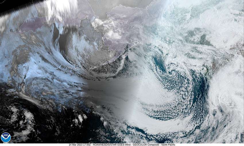
The satellite picture tells the weather story. A large and wet low pressure area is moving across central California as they continue to see more rain and winds bringing catastrophic flooding to some areas, in addition to the damaging winds.

Another low pressure area is seen off the coast of British Columbia moving southeastward towards the top of Vancouver Island. For us, being between systems, we still saw some clouds pushing across today but no rain though there was some showers moving towards the north that remained offshore.

So, for us this evening, between the remnants of the atmospheric river and a weak trough of low pressure, we have an increasing chance of showers tonight especially a little before thru a little after midnight as the trough moves across. Winds tonight westerly 5-10, lows near 37 so the snow level is up around 1800’.

The shower activity eases tomorrow under partly sunny skies, becoming more widely scattered in the afternoon, winds westerly 5-10, highs near 50, then high pressure starts to move in so tomorrow night looks mostly clear which will allow for radiational cooling again, down goes the low to near 33.

Thursday we see mostly sunny skies with winds becoming easterly 5-10, the high climbs up to near 58, then with mostly clear skies that night, the low drops to near 38.

Friday starts out nice with partly sunny skies, the high near 57, then the ridge moves east by Friday night ahead of an upper level trough that will spin up some low pressure systems that drag fronts thru so, we have a chance of rain Friday night into Saturday with rain likely Saturday night into Sunday, and again Monday. Highs remain around 52-57, lows 39-43.

Featured Video

Slide Contribute SUBSCRIBE

Tillamook Weather

Tides

Tillamook County Pioneer Podcast Series

Tillamook Church Search

Cloverdale Baptist Church
Nestucca Valley Presbyterian
Tillamook Ecumenical Service

Archives

  • Home
  • EULA Privacy Policy
  • Contact
  • Opt-out preferences
  • Search...
Share on facebook
Facebook
Share on pinterest
Pinterest
Share on twitter
Twitter
Share on linkedin
Linkedin
Catherine

Recent Posts

  • Tillamook FFA Excels in State Career Development Events: Two Teams Headed to Nationals

    May 12, 2025
  • Tillamook Police Department Invites Community for Coffee with a Cop May 14th

    May 12, 2025
  • GORDON'S WEEKLY WEATHER UPDATE 5/12/25: Showery Pattern Continues Through Week

    May 12, 2025
©2025 | Theme by SuperbThemes

Manage Cookie Consent
To provide the best experiences, we use technologies like cookies to store and/or access device information. Consenting to these technologies will allow us to process data such as browsing behavior or unique IDs on this site. Not consenting or withdrawing consent, may adversely affect certain features and functions.
Functional Always active
The technical storage or access is strictly necessary for the legitimate purpose of enabling the use of a specific service explicitly requested by the subscriber or user, or for the sole purpose of carrying out the transmission of a communication over an electronic communications network.
Preferences
The technical storage or access is necessary for the legitimate purpose of storing preferences that are not requested by the subscriber or user.
Statistics
The technical storage or access that is used exclusively for statistical purposes. The technical storage or access that is used exclusively for anonymous statistical purposes. Without a subpoena, voluntary compliance on the part of your Internet Service Provider, or additional records from a third party, information stored or retrieved for this purpose alone cannot usually be used to identify you.
Marketing
The technical storage or access is required to create user profiles to send advertising, or to track the user on a website or across several websites for similar marketing purposes.
Manage options Manage services Manage {vendor_count} vendors Read more about these purposes
View preferences
{title} {title} {title}