Menu
  • Home
  • Breaking News
  • Feature
    • Arts
    • Astrology
    • Business
    • Community
    • Employment
    • Event Stories
    • From the Pioneer
    • Government
    • Letters to the Editor
    • Non Profit News
    • Obituary
    • Public Safety
    • Podcast Interview Articles
    • Pioneer Pulse Podcast: Politics, Palette, and Planet – the Playlist
  • Weather
  • Guest Column
    • Perspectives
    • Don Backman Photos
    • Ardent Gourmet
    • Kitchen Maven
    • I’ve been thinking
    • Jim Heffernan
    • The Littoral Life
    • Neal Lemery
    • View From Here
    • Virginia Carrell Prowell
    • Words of Wisdom
  • Things to do
    • Calendar
    • Tillamook County Parks
    • Tillamook County Hikes
    • Whale Watching
    • Tillamook County Library
    • SOS Community Calendar
  • About
    • Contribute
    • Advertise
    • Subscribe
    • Opt-out preferences
  • Post Submission Test
  • Search...
Menu

GORDON’S UPDATE: Weather 3/31/23 – Snow in Coast Range Passes this Weekend; Winter Weather Advisory

Posted on March 31, 2023 by Editor
www.tillamookcountypioneer.net

By Gordon McCraw, Meteorologist for the Tillamook County Pioneer
Friday, March 31, 2023

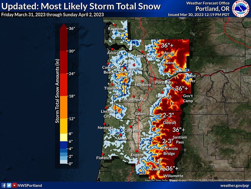
We had a strong cold front move through today that is bringing us some rain and winds as it also pulls the snow level down. After that, we transition over to showers by tomorrow and with the cold, unstable air moving in over the top, we could see some thunderstorms, and maybe some small hail in the heavier showers. These conditions will persist through the weekend. By Saturday night, the snow level will have dropped low enough the top of the passes will start to see snow. From Sunday into next week, we are stuck under a moist northwesterly flow that continues to bring in some showers, and with the nighttime temperature dropping to or near 32, the snow level could drop quite low. After that, things start to slowly warm up, which is good as we are still looking at a chance of showers through the middle of next week.

So, tonight’s forecast, rainy with the breezy winds easing and becoming westerly 10-15 gusting to 20, lows near 38. The snow level, that was up around 3500’ will be falling to near 2000’ tonight, possibly putting 1 to 2’ of snow in the higher Coast Range Mountains and there is a chance that the snow level could continue to fall to near 1500’, impacting the summit by the early morning hours.

We will have transitioned to scattered showers by tomorrow morning, and some of the showers could produce small hail and there is a chance of thunderstorms, winds westerly 10-15 gusting to 20, highs near 49, the snow level around 1800’. Showers, possible hail and/or thunderstorms still tomorrow night, winds westerly 10-15 gusting to 25, lows near 36, the snow level falling to near 1500’ so the Coast Range passes will likely see accumulating snow in the higher elevation summits.

More of the same Sunday, showers with possible hail and/or thunderstorms, winds westerly 8-12 gusting to 18, highs near 45, the snow level remaining at around 1500’ adding more snow to the passes. Sunday night the moisture and unstable conditions remain, and there is a chance of lower snow as the snow level falls to near 1000’ Sunday night and with low temperatures dropping to near 32 in the early morning hours, even lower snowshowers are possible.

So, this means there is a slight chance of seeing low level snowshowers to start on Monday, through around midmorning, then all rain as the snow level lifts from down around 500’ up to near 1500’ by the afternoon, the high climbs to near 49. More showers likely Monday night, lows down to near 34 so the passes are still looking at snow with a chance of low level mixed precipitation in the early morning hours Tuesday.

Tuesday on through Wednesday and into Thursday of next week, still a chance of showers, the snow level climbs to above the passes by Tuesday night, up to 3500’ by Thursday, highs near 50 Tuesday continue to warm, up to near 56 by Thursday, the lows also mellow, though they drop to near 31 Tuesday night, they are back up to near 36 by Thursday night.

Winter just refuses to give in to Spring on this custody battle over the weather. But…Spring will win….eventually!

Featured Video

Slide Contribute SUBSCRIBE

Tillamook Weather

Tides

Tillamook County Pioneer Podcast Series

Tillamook Church Search

Cloverdale Baptist Church
Nestucca Valley Presbyterian
Tillamook Ecumenical Service

Archives

  • Home
  • EULA Privacy Policy
  • Contact
  • Opt-out preferences
  • Search...
Share on facebook
Facebook
Share on pinterest
Pinterest
Share on twitter
Twitter
Share on linkedin
Linkedin
Catherine

Recent Posts

  • BRAVER ANGELS: Oregon Rural Urban Project Town Hall at Tillamook Library May 17th from 1 to 3pm

    May 11, 2025
  • Manzanita Citizen of the Year Nominations Open

    May 11, 2025
  • Support for Christy Kay for NCRD Board

    May 11, 2025
©2025 | Theme by SuperbThemes

Manage Cookie Consent
To provide the best experiences, we use technologies like cookies to store and/or access device information. Consenting to these technologies will allow us to process data such as browsing behavior or unique IDs on this site. Not consenting or withdrawing consent, may adversely affect certain features and functions.
Functional Always active
The technical storage or access is strictly necessary for the legitimate purpose of enabling the use of a specific service explicitly requested by the subscriber or user, or for the sole purpose of carrying out the transmission of a communication over an electronic communications network.
Preferences
The technical storage or access is necessary for the legitimate purpose of storing preferences that are not requested by the subscriber or user.
Statistics
The technical storage or access that is used exclusively for statistical purposes. The technical storage or access that is used exclusively for anonymous statistical purposes. Without a subpoena, voluntary compliance on the part of your Internet Service Provider, or additional records from a third party, information stored or retrieved for this purpose alone cannot usually be used to identify you.
Marketing
The technical storage or access is required to create user profiles to send advertising, or to track the user on a website or across several websites for similar marketing purposes.
Manage options Manage services Manage {vendor_count} vendors Read more about these purposes
View preferences
{title} {title} {title}