
By Gordon McCraw, Meteorologist for the Tillamook County Pioneer
Well, yesterday was certainly a nice day after the dense fog cleared. The afternoon high even made it up to around 70 in most locations. Now today will likely not be as warm but some valley locations could possibly be looking at record highs again. Now, this afternoon things could become a lot more active with a weather potential that is rare for western Oregon.
If you look at the satellite picture it already shows the main player for the real story today. There is a deepening low pressure area in the eastern Pacific, to the west of Oregon, that will be moving northeastward today. This low will swing an area of unstable weather into the area this afternoon, as well as bring increasing southerly winds, becoming 10-15 gusting to 25. Now I am sure many of you have heard about the Severe Thunderstorm potential for today. I can confirm that the Storm Prediction Center has placed a lot of Oregon under a Marginal Risk of Severe Storms today. The Coast though, falls in a Slight Risk area.
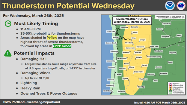
So, what exactly qualifies a storm as Severe? There are several elements that can make a storm officially classified as Severe. Remember, the Coast is only in a Slight Risk area, the valley, including the east side of the Coast Range, is in the higher, or Marginal Risk area.
First, in this case, it can produce Damaging Winds. This is a factor of the outflow from the downdrafts of a storm, combining with the forward speed of the individual cells. To make it Severe it must produce winds 60mph or greater. The current models suggest these storms could produce winds 60-70mph. The NWS suggests there is a 5-14% chance of this around Tillamook.
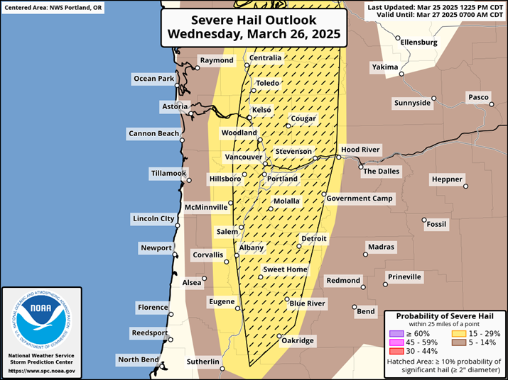
Next is Hail that can also be damaging and hazardous. To be classified as Severe you have to have hail 1” or greater, or around quarter size. The current modeling suggests some areas could see 1 ¾” or Golf Ball size hail, mainly in the valley area. The chance here is less than 10%.
The last item to discuss is the probability of Tornadoes. The chances of this west of the Coast Range during this event are set at around 2-4%.
Now, let’s talk about timing, it looks like there is a slight chance of showers and thunderstorms starting around 1:00pm today which increases and peaking at around 3:00pm today. The storm chance remains until around 7 to 8pm this evening and everything should be done everywhere by around 9:00pm tonight.
So, just to pull it all together for ya, there is a chance of thunderstorms this afternoon that gives us slight risk large hail and strong gusty and damaging winds. There is also a slighter risk of one of these storms may produce a funnel cloud or a tornado. The highest risk times are between 3:00pm amd 7:00pm this evening. Remember also, these storms will likely produce frequent lightning. The bottom line, stay alert this afternoon for rapidly changing conditions and as I always recommend, have a plan. If you see lightning or hear thunder, go indoors, if it starts to hail, go indoors immediately, stay away from windows and skylights, if driving, pull over when safe with your window up, if the strong winds move in, stay away from windows, if driving, pull over to an open area, away from trees, this would include tornadoes when you should also cover your head and neck. Things you can do now, put your car into the garage, clean up things in your yard that can be blown away including garbage cans, lawn furniture, grills and any other things that can become projectiles. Know that we could have power outages and if driving during heavy rain, slow down as the visibility will be impacted as well as hydroplaning risks increase. Remember also, the risks of these severe and damaging storms is actually low, but not zero so it is best to be prepared, just in case!
Now tomorrow and Friday, things will be calmer with only some showers with breezy southeasterly winds 14-18 gusting to 30, the highs back down to near 56, lows near 44.
And as for the weekend, it looks like we will see additional weaker systems moving across that bring periods of showers for Saturday and Sunday, highs in the low 50s, lows in the low 40s.