HELLO, DECEMBER!
By Gordon McCraw, Meteorologist for the Tillamook County Pioneer
A look around the Tillamook area at 9AM this morning showed rainfall totals of ¾” to just over an inch. This is from round one of several more rounds of rain that will impact the region over the next week. Behind this morning’s front we had some unstable air settling in over the area that caused showers with some isolated thunderstorms. So, for tonight, with a strong upper level northwesterly flow we will see more rain pushing in, with southwesterly surface winds of 15 to 25 gusting to near 40, with gusts of 45 to 50 possible at the beaches, the low drops to near 44.
Look for more rain tomorrow, winds westerly 10-15 gusting to 30, the high near 54, then in comes more rain, that could be heavy at times, with another atmospheric river Saturday night, the winds increasing and becoming southwesterly 14 to 18 gusting to 30, the low near 45. As far as rainfall totals for Saturday, maybe around 1 ½” upwards of close to 3” with the higher amounts in the Coast Range. This will begin the significant increase in local river flow rates. With the heavy rain, there could also be some local Urban and Small Stream Flooding from the heavy rain periods.
The rain continues Sunday, that could still be heavy at times, and the southeasterly winds reaching 25-30 gusting to 45 with the beach winds gusting to 50-60, but easing some in the afternoon, afternoon highs up near 58. Sunday night is still rainy and breezy with lows only down near 50. This rain will continue to push the river levels higher Sunday that could be reaching Action Stage on some of the Tillamook County Rivers.
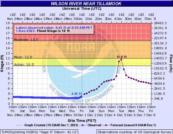
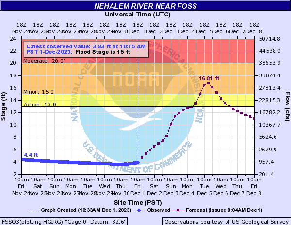
The weekend rainfall totals for the coast are looking to be in the range of 3 to 5” with the Coast Range possibly seeing 4 ½” to 6 ½” over the weekend. This, in and of itself, increases the flooding concerns for the rivers. Then, the models are in agreement that on Monday we are looking at yet another atmosphere river event for the coast. Where they do not agree is exactly who is going to get the heaviest rainfall totals. With the rivers already at high elevated levels, this brings greater concern on the rivers exceeding Flood Stage, and/or climbing even higher into Moderate or Major Flood levels. This morning the NWS River Forecast Center upped the forecasted levels for the Nehalem, which pushed the crest up into Flood Stage with flooding possible starting Monday night through early Wednesday, cresting on Tuesday. They show the Wilson River cresting at Bankfull Tuesday morning. They leave the Trask and the Nestucca River below Action Stage. These levels will likely change with each model run as the system refines the forecast and they all come to better agreement. My best advice is to keep a close eye on all the forecasts, especially the river forecast!
 So, basically, the forecast for next week is easy, cloudy and rainy, the winds breezy, but windy with the Monday system, highs in the mid to upper 50s, lows in the upper 40s to low 50s but cooling after midweek.
What I have overlooked (until just now), is the fact that there is a Beach Hazard Statement warning of increased Sneaker Wave concerns for the period between late tonight through early Wednesday (6th ) morning.
And while I am at it, the National Weather Service Portland has also issued a Flood Watch covering a lot of their area, including Tillamook County, valid from today through Tuesday afternoon. They too recommend that you should monitor later forecasts and be alert for possible Flood Warnings. They suggest that those living in areas prone to flooding should be prepared to take action should flooding develop. Given the rainfall amounts expected this weekend, river levels will be rising quickly so….STAY TUNED.
Listen to Gordon’s KMUN regional weather forecast here: