Menu
  • Home
  • Feature
    • Breaking News
    • Arts
    • Astrology
    • Business
    • Community
    • Employment
    • Event Stories
    • From the Pioneer
    • Government
    • Letters to the Editor
    • Non Profit News
    • Obituary
    • Public Safety
    • Podcast Interview Articles
    • Pioneer Pulse Podcast: Politics, Palette, and Planet – the Playlist
  • Guest Column
    • Perspectives
    • Don Backman Photos
    • Ardent Gourmet
    • Kitchen Maven
    • I’ve been thinking
    • Jim Heffernan
    • The Littoral Life
    • Neal Lemery
    • View From Here
    • Virginia Carrell Prowell
    • Words of Wisdom
  • Weather
  • Post Submission
  • Things to do
    • Calendar
    • Tillamook County Parks
    • Tillamook County Hikes
    • Whale Watching
    • Tillamook County Library
    • SOS Community Calendar
  • About
    • Contribute
    • Advertise
    • Subscribe
    • Opt-out preferences
  • Search...
Menu

GORDON’S UPDATE: Weather 3/1/23 – Pattern continues – Snow level up, snow level down through weekend

Posted on March 1, 2023 by Editor

By Gordon McCraw, Meteorologist for the Tillamook County Pioneer
Wednesday, March 1, 2023

Well, the temperatures were in the upper 20s this morning thanks to the high pressure ridge that is moving across providing the relatively clear skies leading to radiational cooling. We saw some high clouds moving in this evening which are in indicator that we have another frontal system on the way. Still, we had a mostly sunny day, but with the approaching front, tonight we see increasing cloudiness with light southeasterly winds, then after midnight we get an increasing chance of rain with rain likely a few hours after midnight, the lows only dropping to near 41. This spells good news for the Coast Range as the snow level will be lifting to around 2000’ tonight with the initial warm frontal influence.

Tomorrow the cold front pushes in more rain with breezy southerly winds 10-15 gusting to 25, the high near 44; the snow level that had lifted to near 3000’ now begins to fall back down to near 2000’ tomorrow afternoon. The front pushes thru and we transition to scattered showers tomorrow night, winds now westerly 14-18 gusting to 25, lows near 35, the snow level down near 1500’ so the Coast Range will see some snow again all the way down to the summit of Hwy 6 & 26.

The scattered showers persist thru Friday, wind southwesterly 8-12, the high near 45. Friday evening we see the rain moving back in, associated with a low pressure area dropping down from the Gulf of Alaska that persists thru Friday night, the snow level continues to slowly fall, down near 1000’ in the early morning hours with the low temperatures near 34.

Saturday, we continue to be influenced by the low pressure area that is drifting southward along the coast west of Canada and Washington, so rainy Saturday, still breezy, the snow level lifts to near 1500’ during the day, the high near 45. More rain Saturday night, as the snow level starts to fall again to near 1000’, but with the temperatures falling to around 30 that night, low snow is possible in the early morning hours once again.

Sunday the low will be sitting off the Oregon Coast bringing us more rain, or maybe snow to start the morning with the snow level lifting to 500’ that morning, on its way to 1000’ in the afternoon, highs near 45. Then, more rain Sunday night with the snow level falling again, and with the temperatures dropping to near 30 again, more low snow is possible in the early morning hours.

It appears the low will drift south a little by Monday but with the morning temperatures, more morning rain and/or snow is possible thru midmorning, then all rain by late morning, the snow level back up to near 1500’ in the afternoon, highs near 46, but with little changing, the lows drop to near 30 again which means another chance of low snow in the early morning hours for Tuesday.

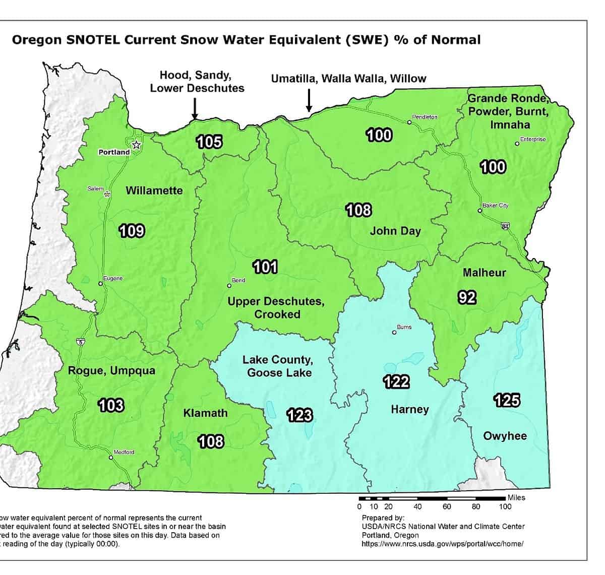
And how much snow is on the ground compared to “normal” for the state. Here is your answer…

Slide Slide Slide Slide Slide Slide Slide Slide Subscribe Contribute

Ads

Featured Video

Tillamook Weather

Tides

Tillamook County Pioneer Podcast Series

Tillamook Church Search

Cloverdale Baptist Church
Nestucca Valley Presbyterian
Tillamook Ecumenical Service

Archives

  • Home
  • EULA Privacy Policy
  • Contact
  • Opt-out preferences
  • Search...
Share on facebook
Facebook
Share on pinterest
Pinterest
Share on twitter
Twitter
Share on linkedin
Linkedin
Catherine

Recent Posts

  • TILLAMOOK COUNTY CREAMERY ASSOCIATION WORK-STUDY PROGRAM CREATES OPPORTUNITIES

    June 30, 2025
  • TILLAMOOK POLICE DEPARTMENT: Damascus Man Sentenced to 28 Years for Attempted Murder of Law Enforcement Officers in Tillamook County

    June 30, 2025
  • BOOK REVIEW: Abundance by Ezra Klein & Derek Thompson

    June 29, 2025
©2025 | Theme by SuperbThemes

Manage Cookie Consent
To provide the best experiences, we use technologies like cookies to store and/or access device information. Consenting to these technologies will allow us to process data such as browsing behavior or unique IDs on this site. Not consenting or withdrawing consent, may adversely affect certain features and functions.
Functional Always active
The technical storage or access is strictly necessary for the legitimate purpose of enabling the use of a specific service explicitly requested by the subscriber or user, or for the sole purpose of carrying out the transmission of a communication over an electronic communications network.
Preferences
The technical storage or access is necessary for the legitimate purpose of storing preferences that are not requested by the subscriber or user.
Statistics
The technical storage or access that is used exclusively for statistical purposes. The technical storage or access that is used exclusively for anonymous statistical purposes. Without a subpoena, voluntary compliance on the part of your Internet Service Provider, or additional records from a third party, information stored or retrieved for this purpose alone cannot usually be used to identify you.
Marketing
The technical storage or access is required to create user profiles to send advertising, or to track the user on a website or across several websites for similar marketing purposes.
Manage options Manage services Manage {vendor_count} vendors Read more about these purposes
View preferences
{title} {title} {title}