Menu
  • Home
  • Feature
    • Breaking News
    • Arts
    • Astrology
    • Business
    • Community
    • Employment
    • Event Stories
    • From the Pioneer
    • Government
    • Letters to the Editor
    • Non Profit News
    • Obituary
    • Public Safety
    • Podcast Interview Articles
    • Pioneer Pulse Podcast: Politics, Palette, and Planet – the Playlist
  • Guest Column
    • Perspectives
    • Don Backman Photos
    • Ardent Gourmet
    • Kitchen Maven
    • I’ve been thinking
    • Jim Heffernan
    • The Littoral Life
    • Neal Lemery
    • View From Here
    • Virginia Carrell Prowell
    • Words of Wisdom
  • Weather
  • Post Submission
  • Things to do
    • Calendar
    • Tillamook County Parks
    • Tillamook County Hikes
    • Whale Watching
    • Tillamook County Library
    • SOS Community Calendar
  • About
    • Contribute
    • Advertise
    • Subscribe
    • Opt-out preferences
  • Search...
Menu

GORDON’S UPDATE: Weekend Edition – Hydrological Outlook – Rising Rivers, Near Action Stage 1/27/24

Posted on January 27, 2024 by Editor

Hydrologic Outlook
National Weather Service Portland OR
235 AM PST Sat Jan 27 2024
…PERIODS OF HEAVY RAIN WITH RISING RIVERS THIS WEEKEND…
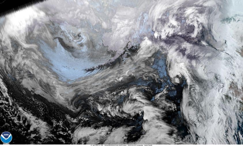
A complex area of low pressure offshore will maintain mild and moist southwest flow into the region through Sunday morning. This will bring rain, heavy at times, to northwest Oregon and southwest Washington. Rainfall of 1 to 3 inches is expected across the region, with 2 to 5 inches over the Willapa Hills, Coast Range and the south Washington Cascades through Sunday morning. Snow levels will be rising Friday, and hover at 7000 to 8000 feet through the weekend. Rain tapers off Sunday into Monday.
With all this rain, and snowmelt from the Coast Range and Cascades, rivers will be rising. Many small streams and creeks will be running high into Sunday. Heavy rainfall will cause water ponding in low lying areas and other areas of poor drainage.
In addition to hydrologic impacts, there may also be an elevated landslide risk. These particularly affects those areas that have seen significant tree damage due to then recent and strong east winds.
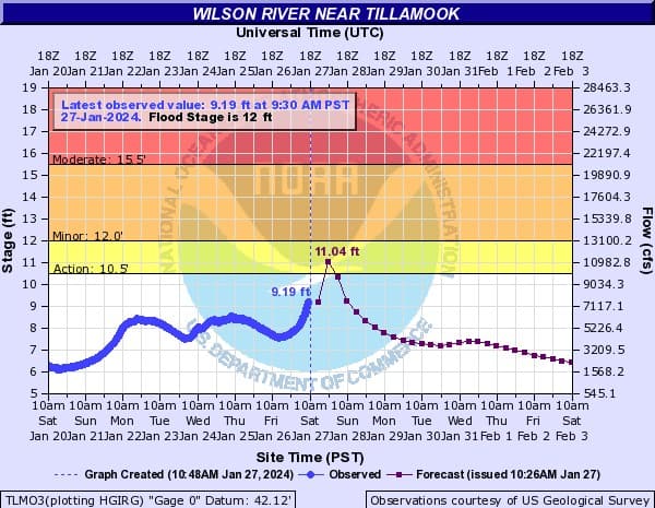
This morning’s river forecasts which are a little higher — they pushed the Wilson into Action Stage, Latest predictions for the Wilson River –
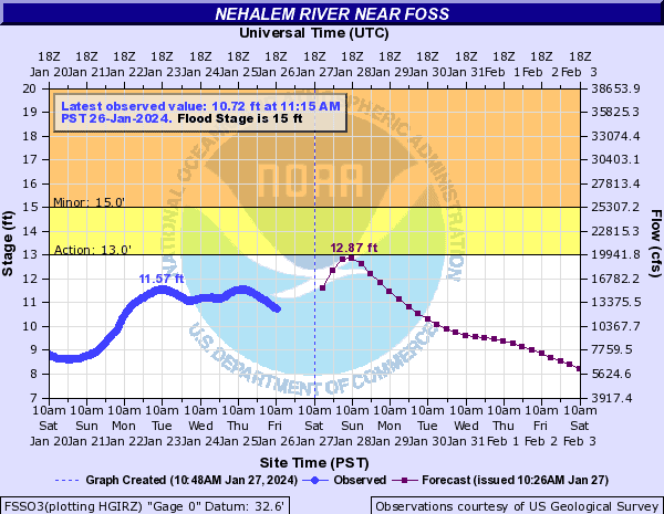
Cresting at 11.04 at 10 pm tonight, Flood Stage is 12.0′. The Nehalem River also will be at bankfull, and the gauge is currently not operating. The Pioneer has reported this to Tillamook County Emergency Management and the National Weather Service/NOAA have been notified.

Tillamook: It looks like we had a low pressure area form near the coast and move across the area this morning, coming ashore south of Tillamook headed to the northeast. This brought moderate, occasionally heavy rain through Tillamook County which has caused the rivers to climb but none are expected to reach Flood Stage though the Wilson River is expected to reach near bankfull. The good news for the Tillamook area is that the heavier rain is pulling off to the northeast leaving some light rain in its wake. We are seeing some increased southerly winds this morning along the coast, 15-20 gusting to near 40. Total rainfall for the last 24hr in the Tillamook area in the range of 2-3″ while some Coast Range locations are report between 3-4″.
More rain is on the way Tillamook with an atmospheric river of sorts developing with plenty of moisture on the satellite picture being pushed to the northeast in the persistent southwesterly flow. This means you can expect more rain with breezy southerly winds that do ease late tonight. With that strong and persistent southwesterly flow, the low tonight hangs at around 56.

Slide Slide Slide Slide Slide Slide Slide Slide Subscribe Contribute

Ads

Featured Video

Tillamook Weather

Tides

Tillamook County Pioneer Podcast Series

Tillamook Church Search

Cloverdale Baptist Church
Nestucca Valley Presbyterian
Tillamook Ecumenical Service

Archives

  • Home
  • EULA Privacy Policy
  • Contact
  • Opt-out preferences
  • Search...
Share on facebook
Facebook
Share on pinterest
Pinterest
Share on twitter
Twitter
Share on linkedin
Linkedin
Catherine

Recent Posts

  • TILLAMOOK COUNTY CREAMERY ASSOCIATION WORK-STUDY PROGRAM CREATES OPPORTUNITIES

    June 30, 2025
  • TILLAMOOK POLICE DEPARTMENT: Damascus Man Sentenced to 28 Years for Attempted Murder of Law Enforcement Officers in Tillamook County

    June 30, 2025
  • BOOK REVIEW: Abundance by Ezra Klein & Derek Thompson

    June 29, 2025
©2025 | Theme by SuperbThemes

Manage Cookie Consent
To provide the best experiences, we use technologies like cookies to store and/or access device information. Consenting to these technologies will allow us to process data such as browsing behavior or unique IDs on this site. Not consenting or withdrawing consent, may adversely affect certain features and functions.
Functional Always active
The technical storage or access is strictly necessary for the legitimate purpose of enabling the use of a specific service explicitly requested by the subscriber or user, or for the sole purpose of carrying out the transmission of a communication over an electronic communications network.
Preferences
The technical storage or access is necessary for the legitimate purpose of storing preferences that are not requested by the subscriber or user.
Statistics
The technical storage or access that is used exclusively for statistical purposes. The technical storage or access that is used exclusively for anonymous statistical purposes. Without a subpoena, voluntary compliance on the part of your Internet Service Provider, or additional records from a third party, information stored or retrieved for this purpose alone cannot usually be used to identify you.
Marketing
The technical storage or access is required to create user profiles to send advertising, or to track the user on a website or across several websites for similar marketing purposes.
Manage options Manage services Manage {vendor_count} vendors Read more about these purposes
View preferences
{title} {title} {title}