Menu
  • Home
  • Breaking News
  • Feature
    • Arts
    • Astrology
    • Business
    • Community
    • Employment
    • Event Stories
    • From the Pioneer
    • Government
    • Letters to the Editor
    • Non Profit News
    • Obituary
    • Public Safety
    • Podcast Interview Articles
    • Pioneer Pulse Podcast: Politics, Palette, and Planet – the Playlist
  • Weather
  • Guest Column
    • Perspectives
    • Don Backman Photos
    • Ardent Gourmet
    • Kitchen Maven
    • I’ve been thinking
    • Jim Heffernan
    • The Littoral Life
    • Neal Lemery
    • View From Here
    • Virginia Carrell Prowell
    • Words of Wisdom
  • Things to do
    • Calendar
    • Tillamook County Parks
    • Tillamook County Hikes
    • Whale Watching
    • Tillamook County Library
    • SOS Community Calendar
  • About
    • Contribute
    • Advertise
    • Subscribe
    • Opt-out preferences
  • Post Submission Test
  • Search...
Menu

GORDON’S WEEKLY WEATHER UPDATE 12/16/24: A Wet Week to Welcome Winter

Posted on December 16, 2024 by Editor

By Gordon McCraw, Meteorologist for the Tillamook County Pioneer
Monday, December 16, 2024

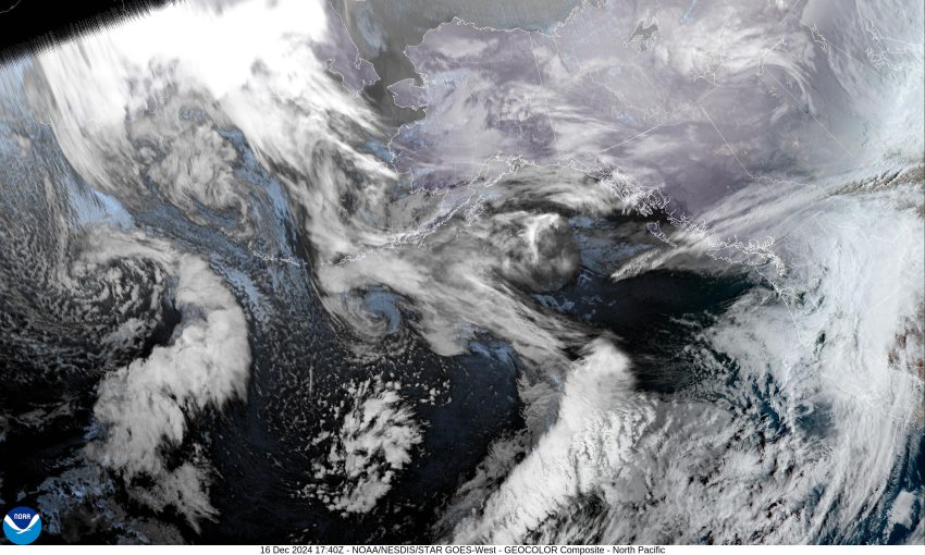
It looks like we are in for another wet week with several fronts expected to bring rain to the coast pretty much all week. Today, we had a low pressure area over the Pacific that pushed a front across. Now we see showers associated with a trough swing in on the southwesterly flow. Later tonight, we see another warm front approaching and bringing in heavier rain with southerly winds 5-10, the low temperature only down to near 47.

Tomorrow sees more rain with the front, an Atmospheric River event with the rain heavy at times, and breezy southerly winds 8-12 to start but increasing to 15-10 gusting to 35 in the afternoon with gusts 45-50 possible at the beaches, the high near 56. Rainfall totals from this system likely around 1-2” at the coast, possibly as much as 3 to 5” in the Coast Range, then with the rain easing some tomorrow night as the system drifts northward, we are looking at around ½ to ¾” of additional rain. The winds remain gusty until the early morning hours when they finally ease, overnight lows near 47 once again. The chance of river flooding, while not zero, is currently low but bears watching.
A High Wind Watch has been issued from Tuesday afternoon through early Wednesday morning.

The southwesterly flow pushes another fast-moving cold front across later Wednesday morning, winds southerly 5-10, highs near 57. More rain is expected Wednesday night with yet another system, lows near 44.

Thursday on through the weekend, the weather gets a little chaotic so the models are a little mixed. It appears there will be a ridge to the east with a trough of low pressure offshore to our west, keeping us under a southwesterly flow that provides a flow for disturbances to ride in and bring rain, off and on mainly along the coast to the Coast Range. We continue to see moderate temperatures with highs 55-60, lows 44-49.

By the way, there is a big event happening on Saturday, December 21st did you know that day is just under 7 hours shorter than it was in June? Known as the Winter Solstice, it is the shortest day of the year for most folks in the Northern Hemisphere.

Welcome to the first day of Winter!

Featured Video

Slide Contribute SUBSCRIBE

Tillamook Weather

Tides

Tillamook County Pioneer Podcast Series

Tillamook Church Search

Cloverdale Baptist Church
Nestucca Valley Presbyterian
Tillamook Ecumenical Service

Archives

  • Home
  • EULA Privacy Policy
  • Contact
  • Opt-out preferences
  • Search...
Share on facebook
Facebook
Share on pinterest
Pinterest
Share on twitter
Twitter
Share on linkedin
Linkedin
Catherine

Recent Posts

  • GORDON'S WEEKEND WEATHER UPDATE 5/15/25: More showers and slight threat of thunderstorms

    May 15, 2025
  • NEHALEM BAY STATE PARK TO OPEN DAY-USE AREAS, BOAT LAUNCH MAY 23, CAMPGROUND REMAINS CLOSED

    May 14, 2025
  • MANZANITA FARMERS MARKET OPENS FRIDAY MAY 16TH!!

    May 14, 2025
©2025 | Theme by SuperbThemes

Manage Cookie Consent
To provide the best experiences, we use technologies like cookies to store and/or access device information. Consenting to these technologies will allow us to process data such as browsing behavior or unique IDs on this site. Not consenting or withdrawing consent, may adversely affect certain features and functions.
Functional Always active
The technical storage or access is strictly necessary for the legitimate purpose of enabling the use of a specific service explicitly requested by the subscriber or user, or for the sole purpose of carrying out the transmission of a communication over an electronic communications network.
Preferences
The technical storage or access is necessary for the legitimate purpose of storing preferences that are not requested by the subscriber or user.
Statistics
The technical storage or access that is used exclusively for statistical purposes. The technical storage or access that is used exclusively for anonymous statistical purposes. Without a subpoena, voluntary compliance on the part of your Internet Service Provider, or additional records from a third party, information stored or retrieved for this purpose alone cannot usually be used to identify you.
Marketing
The technical storage or access is required to create user profiles to send advertising, or to track the user on a website or across several websites for similar marketing purposes.
Manage options Manage services Manage {vendor_count} vendors Read more about these purposes
View preferences
{title} {title} {title}