Menu
  • Home
  • Feature
    • Breaking News
    • Arts
    • Astrology
    • Business
    • Community
    • Employment
    • Event Stories
    • From the Pioneer
    • Government
    • Letters to the Editor
    • Non Profit News
    • Obituary
    • Public Safety
    • Podcast Interview Articles
    • Pioneer Pulse Podcast: Politics, Palette, and Planet – the Playlist
  • Guest Column
    • Perspectives
    • Don Backman Photos
    • Ardent Gourmet
    • Kitchen Maven
    • I’ve been thinking
    • Jim Heffernan
    • The Littoral Life
    • Neal Lemery
    • View From Here
    • Virginia Carrell Prowell
    • Words of Wisdom
  • Weather
  • Post Submission
  • Things to do
    • Calendar
    • Tillamook County Parks
    • Tillamook County Hikes
    • Whale Watching
    • Tillamook County Library
    • SOS Community Calendar
  • About
    • Contribute
    • Advertise
    • Subscribe
    • Opt-out preferences
  • Search...
Menu

OREGON DEPARTMENT OF FORESTRY FIRE REPORT AND FIRE MAP FOR WEDNESDAY, SEPT. 30, 2020

Posted on September 30, 2020September 30, 2020 by Editor

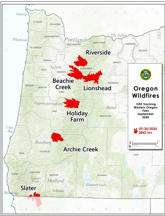
SALEM, Ore. – ODF is closely tracking 6 major fires in Oregon, down from 17 originally (see table below for details). Fires are removed from the list when they are 100% lined and fire managers are confident in their progress toward containment.
There have been more than 7,500 personnel from 39 states and multiple Canadian provinces assigned to fires in Oregon since Labor Day. This number doesn’t include many of the government employees, landowners, forestland operators, and members of the community who fought alongside and supported firefighting personnel over the past few weeks.
More than 1 million acres have burned in Oregon since the start of this year, which is nearly double the 10-year average of approximately 557,811.

Fire name Acres burned Containment Location
Lionshead 204,355 35% 20 miles W of Warm Springs
Beachie Creek 192,848 58% 15 miles N of Detroit
Holiday Farm 173,094 65% 3 miles W of McKenzie Bridge
Riverside 138,029 37% 2 miles SE of Estacada
Archie Creek 131,542 73% 20 miles E of Glide
Slater 44,286 in Oregon 40% 6 SE of Cave Junction (also in No. California)


More information

  • ODF wildfire blog and Significant Fire Potential Map
  • Northwest Coordination Center – Regional Update and National Situation Report
  • Inciweb (information on individual incidents)

Featured Video

Ads

Slide Slide Slide Slide Slide Slide Slide Slide Subscribe Contribute

Tillamook Weather

Tides

Tillamook County Pioneer Podcast Series

Tillamook Church Search

Cloverdale Baptist Church
Nestucca Valley Presbyterian
Tillamook Ecumenical Service

Archives

  • Home
  • EULA Privacy Policy
  • Contact
  • Opt-out preferences
  • Search...
Share on facebook
Facebook
Share on pinterest
Pinterest
Share on twitter
Twitter
Share on linkedin
Linkedin
Catherine

Recent Posts

  • FRIENDS OF NETARTS BAY WEBS PRESENTS: TIDEPOOL DISCOVERY DAYS JUNE 26-28

    June 24, 2025
  • UNITED PAWS KITTENS OF THE WEEK: Bonzai, Poppy, Pippin & Sprout; Seeking Foster Volunteers

    June 24, 2025
  • OBITUARY: Betty Jean McMahon - June 18, 1947 - June 14, 2025

    June 24, 2025
©2025 | Theme by SuperbThemes

Manage Cookie Consent
To provide the best experiences, we use technologies like cookies to store and/or access device information. Consenting to these technologies will allow us to process data such as browsing behavior or unique IDs on this site. Not consenting or withdrawing consent, may adversely affect certain features and functions.
Functional Always active
The technical storage or access is strictly necessary for the legitimate purpose of enabling the use of a specific service explicitly requested by the subscriber or user, or for the sole purpose of carrying out the transmission of a communication over an electronic communications network.
Preferences
The technical storage or access is necessary for the legitimate purpose of storing preferences that are not requested by the subscriber or user.
Statistics
The technical storage or access that is used exclusively for statistical purposes. The technical storage or access that is used exclusively for anonymous statistical purposes. Without a subpoena, voluntary compliance on the part of your Internet Service Provider, or additional records from a third party, information stored or retrieved for this purpose alone cannot usually be used to identify you.
Marketing
The technical storage or access is required to create user profiles to send advertising, or to track the user on a website or across several websites for similar marketing purposes.
Manage options Manage services Manage {vendor_count} vendors Read more about these purposes
View preferences
{title} {title} {title}