Menu
  • Home
  • Feature
    • Breaking News
    • Arts
    • Astrology
    • Business
    • Community
    • Employment
    • Event Stories
    • From the Pioneer
    • Government
    • Letters to the Editor
    • Non Profit News
    • Obituary
    • Public Safety
    • Podcast Interview Articles
    • Pioneer Pulse Podcast: Politics, Palette, and Planet – the Playlist
  • Guest Column
    • Perspectives
    • Don Backman Photos
    • Ardent Gourmet
    • Kitchen Maven
    • I’ve been thinking
    • Jim Heffernan
    • The Littoral Life
    • Neal Lemery
    • View From Here
    • Virginia Carrell Prowell
    • Words of Wisdom
  • Weather
  • Post Submission
  • Things to do
    • Calendar
    • Tillamook County Parks
    • Tillamook County Hikes
    • Whale Watching
    • Tillamook County Library
    • SOS Community Calendar
  • About
    • Contribute
    • Advertise
    • Subscribe
    • Opt-out preferences
  • Search...
Menu

TILLAMOOK COUNTY EMERGENCY MANAGEMENT: National Weather Service Update 2/22/23; Cold Temperatures and Chances for Lowland Snow

Posted on February 22, 2023February 22, 2023 by Editor

National Weather Service
National Oceanic and Atmospheric Administration
Wednesday, Feb 22, 2023
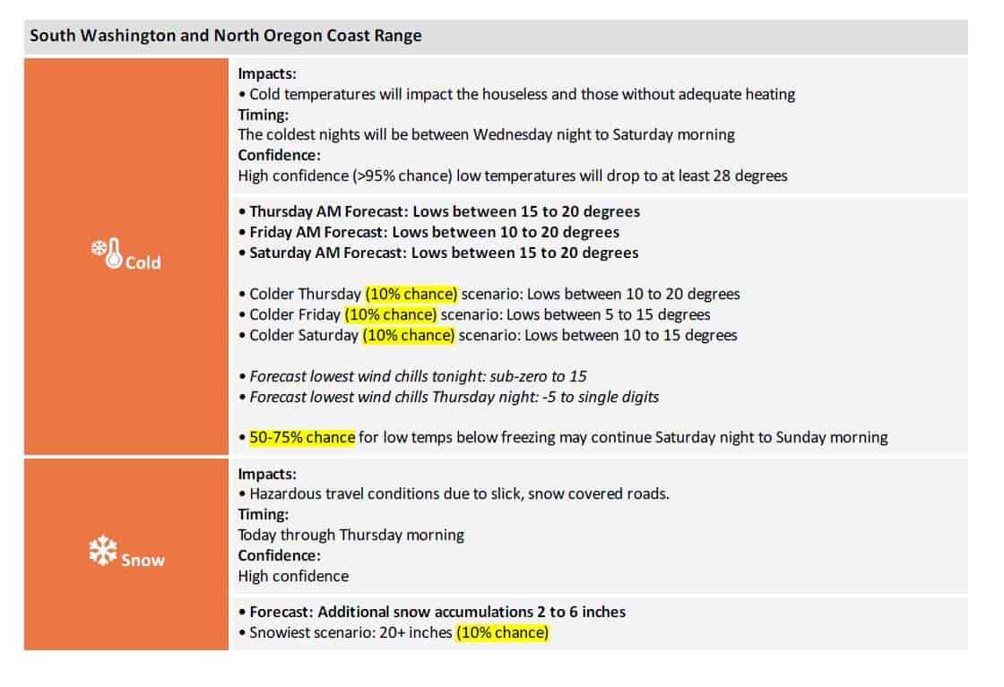
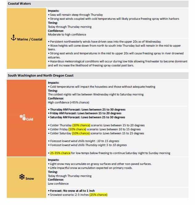
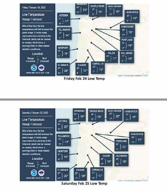
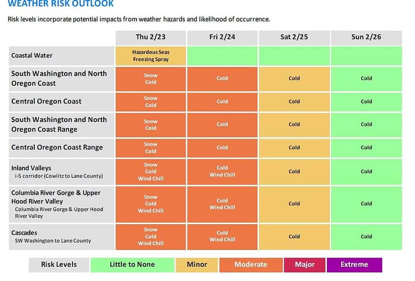
A cutoff low will continue to track south along the coast into the weekend pulling cold air west of the Cascades bringing dangerously cold
temperatures and varying snow accumulations across the area. Forecast confidence remains high (>95% chance) that temperatures will become cold tonight and last through Saturday morning. Wrap around moisture within the low will increase snow across much of the area, but confidence remains low when it comes to the exact snow amounts and location of the precipitation through Thursday morning.
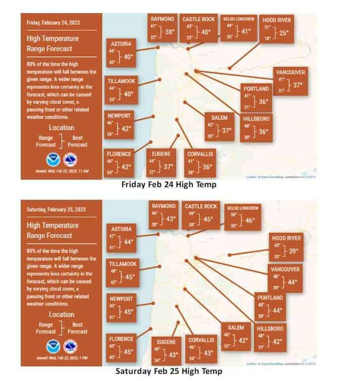
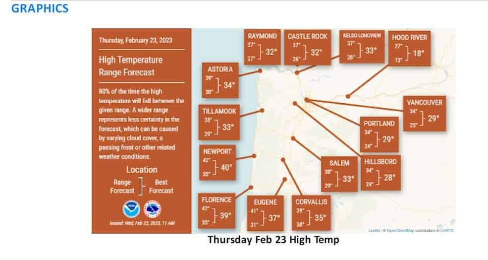
The highest snowfall totals are expected across the Portland/Vancouver Metro & the I-5 Corridor in SW Washington. Temperatures are going to continue to fall this afternoon and evening and result in water and slush on surfaces freezing. Below freezing temperatures will take longer to reach areas from Salem southward, which will likely freeze after midnight.

KEY POINTS
– High confidence (>95% chance) we will experience colder temperatures across the region today through Saturday morning.
– Coldest temperatures expected Wednesday night – Saturday morning, but east winds will make it feel colder.
– Snow will diminish across the area overnight into Thursday
– Wind Chills tonight and Thursday night will cause temperatures feel very cold.
CHANGES FROM PREVIOUS BRIEFING
• Updated snowfall amounts/probabilities and temperatures
• Added Wind Chill

Slide Slide Slide Slide Slide Slide Slide Slide Subscribe Contribute

Ads

Featured Video

Tillamook Weather

Tides

Tillamook County Pioneer Podcast Series

Tillamook Church Search

Cloverdale Baptist Church
Nestucca Valley Presbyterian
Tillamook Ecumenical Service

Archives

  • Home
  • EULA Privacy Policy
  • Contact
  • Opt-out preferences
  • Search...
Share on facebook
Facebook
Share on pinterest
Pinterest
Share on twitter
Twitter
Share on linkedin
Linkedin
Catherine

Recent Posts

  • TILLAMOOK COUNTY CREAMERY ASSOCIATION WORK-STUDY PROGRAM CREATES OPPORTUNITIES

    June 30, 2025
  • TILLAMOOK POLICE DEPARTMENT: Damascus Man Sentenced to 28 Years for Attempted Murder of Law Enforcement Officers in Tillamook County

    June 30, 2025
  • BOOK REVIEW: Abundance by Ezra Klein & Derek Thompson

    June 29, 2025
©2025 | Theme by SuperbThemes

Manage Cookie Consent
To provide the best experiences, we use technologies like cookies to store and/or access device information. Consenting to these technologies will allow us to process data such as browsing behavior or unique IDs on this site. Not consenting or withdrawing consent, may adversely affect certain features and functions.
Functional Always active
The technical storage or access is strictly necessary for the legitimate purpose of enabling the use of a specific service explicitly requested by the subscriber or user, or for the sole purpose of carrying out the transmission of a communication over an electronic communications network.
Preferences
The technical storage or access is necessary for the legitimate purpose of storing preferences that are not requested by the subscriber or user.
Statistics
The technical storage or access that is used exclusively for statistical purposes. The technical storage or access that is used exclusively for anonymous statistical purposes. Without a subpoena, voluntary compliance on the part of your Internet Service Provider, or additional records from a third party, information stored or retrieved for this purpose alone cannot usually be used to identify you.
Marketing
The technical storage or access is required to create user profiles to send advertising, or to track the user on a website or across several websites for similar marketing purposes.
Manage options Manage services Manage {vendor_count} vendors Read more about these purposes
View preferences
{title} {title} {title}