Menu
  • Home
  • Breaking News
  • Feature
    • Arts
    • Astrology
    • Business
    • Community
    • Employment
    • Event Stories
    • From the Pioneer
    • Government
    • Letters to the Editor
    • Non Profit News
    • Obituary
    • Public Safety
    • Podcast Interview Articles
    • Pioneer Pulse Podcast: Politics, Palette, and Planet – the Playlist
  • Weather
  • Guest Column
    • Perspectives
    • Don Backman Photos
    • Ardent Gourmet
    • Kitchen Maven
    • I’ve been thinking
    • Jim Heffernan
    • The Littoral Life
    • Neal Lemery
    • View From Here
    • Virginia Carrell Prowell
    • Words of Wisdom
  • Things to do
    • Calendar
    • Tillamook County Parks
    • Tillamook County Hikes
    • Whale Watching
    • Tillamook County Library
    • SOS Community Calendar
  • About
    • Contribute
    • Advertise
    • Subscribe
    • Opt-out preferences
  • Post Submission Test
  • Search...
Menu

TILLAMOOK COUNTY EMERGENCY MANAGEMENT: National Weather Service – Weather Forecast Office Portland Friday, Dec 20, 2024

Posted on December 20, 2024 by Editor
National Weather Service
National Oceanic and Atmospheric Administration
Active Weather This Weekend (12/20) through Next Week – A Quick Update
KEY POINTS
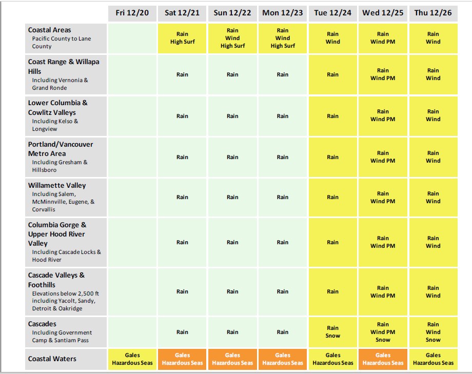
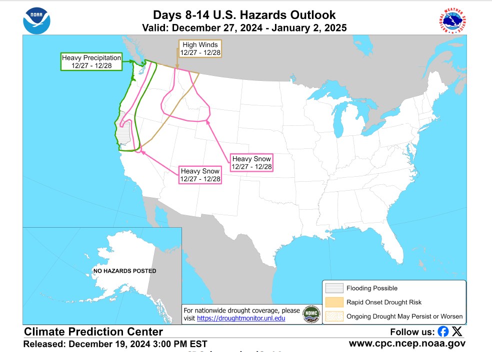
• A series of weather systems will bring widespread rain, periods of gusty winds, and high elevation Cascade snow to the region Saturday through next week.
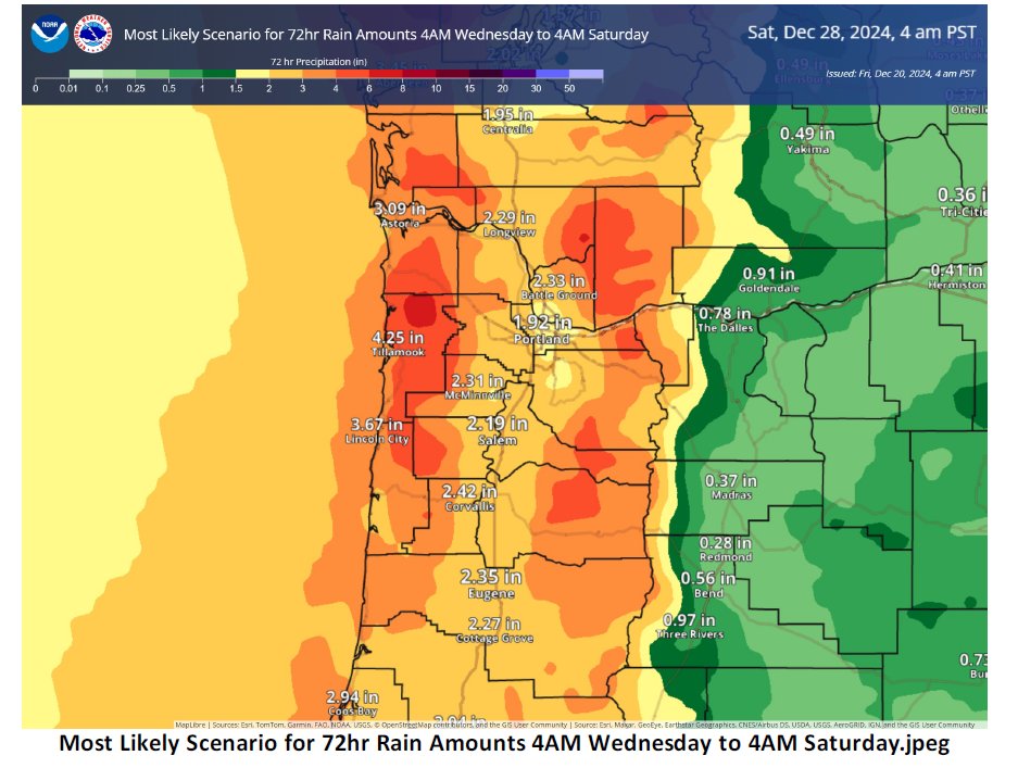
• Rivers could rise slightly due to rainfall amounts Saturday (12/21) – Tuesday (12/24), but the time period of most concern for river flooding is with a potentially stronger storm system late Wednesday (12/25) – Thursday (12/26) and beyond. Uncertainty in river flooding potential next week remains high due to high uncertainties in rain amounts over river basins. Continue to monitor water.noaa.gov/wfo/pqr to view latest river forecasts and flood probabilities.

• Cascade snow will mainly remain above pass level (5,000-6,000+ ft) through Monday (12/23). Snow levels may fall below pass level Tuesday (12/24) and beyond, though mainly during lighter periods of precipitation, resulting in limited snow amounts over passes.
• Gusty winds expected along the coast with each weather system through Tuesday (12/24). Gusts up to 40-50 mph at times could produce downed tree limbs and weak trees. Widespread breezy to gusty winds possible Wednesday night (12/25) into Thursday (12/26) with stronger gusts along the coast which could produce downed trees and powerlines and localized power outages.
• Active weather over the Pacific will bring periods of hazardous seas and gales to the coastal waters Saturday (12/21) through next week. There is a 60-80% probability of significant wave heights exceeding 20 ft on Saturday (12/21) through Wednesday (12/25). Highest seas are currently expected on Monday (12/23)
CHANGES FROM PREVIOUS BRIEFING
-Reduced rain risk level from “minor” to “little to no risk” Saturday (12/21) through Monday (12/23).
-Upgraded Hazardous Seas to Moderate risk Saturday (12/21) through Monday (12/23), and Wednesday (12/25).
-Added rain and wind to Thursday (12/26) portion of the matrix for most areas – Gales and Hazardous seas Coastal Waters.

Featured Video

Slide Contribute SUBSCRIBE

Tillamook Weather

Tides

Tillamook County Pioneer Podcast Series

Tillamook Church Search

Cloverdale Baptist Church
Nestucca Valley Presbyterian
Tillamook Ecumenical Service

Archives

  • Home
  • EULA Privacy Policy
  • Contact
  • Opt-out preferences
  • Search...
Share on facebook
Facebook
Share on pinterest
Pinterest
Share on twitter
Twitter
Share on linkedin
Linkedin
Catherine

Recent Posts

  • GORDON'S WEEKEND WEATHER UPDATE 5/15/25: More showers and slight threat of thunderstorms

    May 15, 2025
  • NEHALEM BAY STATE PARK TO OPEN DAY-USE AREAS, BOAT LAUNCH MAY 23, CAMPGROUND REMAINS CLOSED

    May 14, 2025
  • MANZANITA FARMERS MARKET OPENS FRIDAY MAY 16TH!!

    May 14, 2025
©2025 | Theme by SuperbThemes

Manage Cookie Consent
To provide the best experiences, we use technologies like cookies to store and/or access device information. Consenting to these technologies will allow us to process data such as browsing behavior or unique IDs on this site. Not consenting or withdrawing consent, may adversely affect certain features and functions.
Functional Always active
The technical storage or access is strictly necessary for the legitimate purpose of enabling the use of a specific service explicitly requested by the subscriber or user, or for the sole purpose of carrying out the transmission of a communication over an electronic communications network.
Preferences
The technical storage or access is necessary for the legitimate purpose of storing preferences that are not requested by the subscriber or user.
Statistics
The technical storage or access that is used exclusively for statistical purposes. The technical storage or access that is used exclusively for anonymous statistical purposes. Without a subpoena, voluntary compliance on the part of your Internet Service Provider, or additional records from a third party, information stored or retrieved for this purpose alone cannot usually be used to identify you.
Marketing
The technical storage or access is required to create user profiles to send advertising, or to track the user on a website or across several websites for similar marketing purposes.
Manage options Manage services Manage {vendor_count} vendors Read more about these purposes
View preferences
{title} {title} {title}