Menu
  • Home
  • Breaking News
  • Feature
    • Arts
    • Astrology
    • Business
    • Community
    • Employment
    • Event Stories
    • From the Pioneer
    • Government
    • Letters to the Editor
    • Non Profit News
    • Obituary
    • Public Safety
    • Podcast Interview Articles
    • Pioneer Pulse Podcast: Politics, Palette, and Planet – the Playlist
  • Weather
  • Guest Column
    • Perspectives
    • Don Backman Photos
    • Ardent Gourmet
    • Kitchen Maven
    • I’ve been thinking
    • Jim Heffernan
    • The Littoral Life
    • Neal Lemery
    • View From Here
    • Virginia Carrell Prowell
    • Words of Wisdom
  • Things to do
    • Calendar
    • Tillamook County Parks
    • Tillamook County Hikes
    • Whale Watching
    • Tillamook County Library
    • SOS Community Calendar
  • About
    • Contribute
    • Advertise
    • Subscribe
    • Opt-out preferences
  • Post Submission Test
  • Search...
Menu

TILLAMOOK COUNTY EMERGENCY MANAGEMENT: Gordon’s Update – Weather – 9/13/21

Posted on September 13, 2021 by Editor

By Gordon McCraw, Tillamook County Emergency Manager
Monday, September 13, 2021, 10:45am

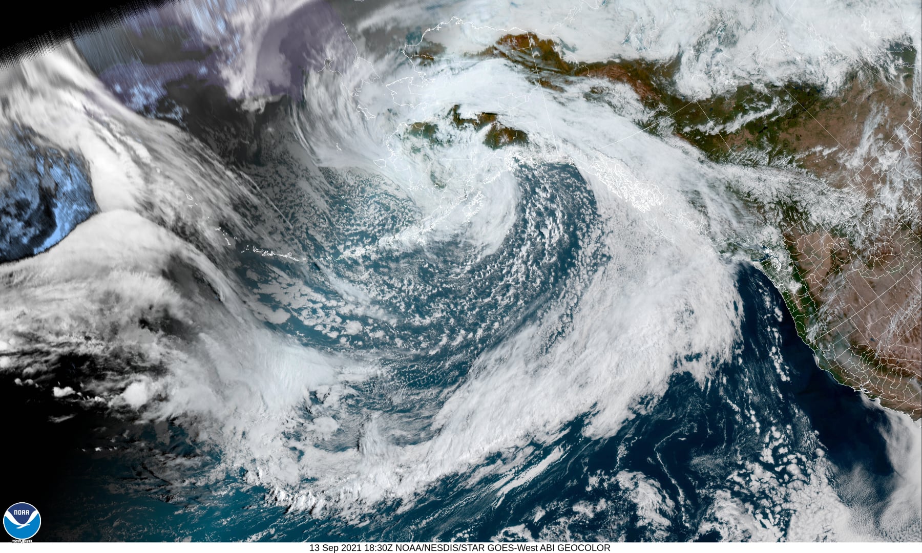
The next few days will see no significant changes, then, we likely see some actual measurable precipitation moving in by Friday with the strongest front that we have seen in quite some time bringing a couple of inches of rain along with breezy conditions thru the weekend.
Today and tomorrow we have a weak ridge of high pressure that warms us a few degrees and brings some patchy morning fog tomorrow, highs today near 68, lows tonight, under mostly clear skies, down near 44.
Tomorrow night we have a weak and dying front move over that increases the onshore flow and thickens the marine layer that will give us a chance of patchy drizzle tomorrow night and early morning Wednesday. High temperatures tomorrow in the low 70s, with the clouds, tomorrow night’s lows near 49.

Wednesday looks cooler with partly sunny skies, the highs near 65, lows near 40, also a little on the breezy side with northwesterly winds 8-12 gusting to 20-25, then Thursday we start out mostly sunny, the high near 66, but that night some clouds start pushing in announcing the approach of a front that will bring rainy conditions early Friday morning.
So, Friday it looks like we see a decent front moving in that will bring moderate rain, possible even brief heavy rains to some areas, and gusty southwesterly winds Friday night into early Saturday morning. The beaches could see southerly winds 35-45 for a change. Once the front pushes through later Saturday we will see showers, possibly even some thunderstorms that start to become more scattered Saturday night. High temperatures Friday and Saturday in the low 60s, lows in the upper 40s.
The shower threat increases Sunday with daytime heating, even with the continued cloudy skies, highs in the low 60s, lows in the mid 40s.
Rainfall totals for this Atmospheric River event appear to be in the 2 to 3” range for Friday thru Sunday. With the prolonged dry conditions, the ground will be absorbing a lot of the rain, but the rivers will still see a slight increase in flow rates. This is a good thing as many of the rivers are currently at record low levels.

Featured Video

Slide Contribute SUBSCRIBE

Tillamook Weather

Tides

Tillamook County Pioneer Podcast Series

Tillamook Church Search

Cloverdale Baptist Church
Nestucca Valley Presbyterian
Tillamook Ecumenical Service

Archives

  • Home
  • EULA Privacy Policy
  • Contact
  • Opt-out preferences
  • Search...
Share on facebook
Facebook
Share on pinterest
Pinterest
Share on twitter
Twitter
Share on linkedin
Linkedin
Catherine

Recent Posts

  • Dramatic Dog Rescue at Cape Kiwanda Sunday May 11th Netarts Oceanside Fire District & Nestucca Rural Fire District Respond, Skilled Rope Rescue Team in Action, Brings Journey to Safety

    May 13, 2025
  • News from the Nehalem Bay Health District: Nehalem Bay Health Center and Pharmacy Update - Hospital Road Closure Wed. 5/14

    May 13, 2025
  • GET OUT THE VOTE! Tillamook County Democrats Elect Candidates that Work for EVERY Citizen

    May 13, 2025
©2025 | Theme by SuperbThemes

Manage Cookie Consent
To provide the best experiences, we use technologies like cookies to store and/or access device information. Consenting to these technologies will allow us to process data such as browsing behavior or unique IDs on this site. Not consenting or withdrawing consent, may adversely affect certain features and functions.
Functional Always active
The technical storage or access is strictly necessary for the legitimate purpose of enabling the use of a specific service explicitly requested by the subscriber or user, or for the sole purpose of carrying out the transmission of a communication over an electronic communications network.
Preferences
The technical storage or access is necessary for the legitimate purpose of storing preferences that are not requested by the subscriber or user.
Statistics
The technical storage or access that is used exclusively for statistical purposes. The technical storage or access that is used exclusively for anonymous statistical purposes. Without a subpoena, voluntary compliance on the part of your Internet Service Provider, or additional records from a third party, information stored or retrieved for this purpose alone cannot usually be used to identify you.
Marketing
The technical storage or access is required to create user profiles to send advertising, or to track the user on a website or across several websites for similar marketing purposes.
Manage options Manage services Manage {vendor_count} vendors Read more about these purposes
View preferences
{title} {title} {title}