Menu
  • Home
  • Breaking News
  • Feature
    • Arts
    • Astrology
    • Business
    • Community
    • Employment
    • Event Stories
    • From the Pioneer
    • Government
    • Letters to the Editor
    • Non Profit News
    • Obituary
    • Public Safety
    • Podcast Interview Articles
    • Pioneer Pulse Podcast: Politics, Palette, and Planet – the Playlist
  • Weather
  • Guest Column
    • Perspectives
    • Don Backman Photos
    • Ardent Gourmet
    • Kitchen Maven
    • I’ve been thinking
    • Jim Heffernan
    • The Littoral Life
    • Neal Lemery
    • View From Here
    • Virginia Carrell Prowell
    • Words of Wisdom
  • Things to do
    • Calendar
    • Tillamook County Parks
    • Tillamook County Hikes
    • Whale Watching
    • Tillamook County Library
    • SOS Community Calendar
  • About
    • Contribute
    • Advertise
    • Subscribe
    • Opt-out preferences
  • Post Submission Test
  • Search...
Menu

GORDON’S WEEKLY WEATHER UPDATE 10/28/24: Rainshowers, Thunderstorms Throughout the Week; Typical Halloween – Wet, Windy

Posted on October 28, 2024 by Editor

By Gordon McCraw, Meteorologist for the Tillamook County Pioneer
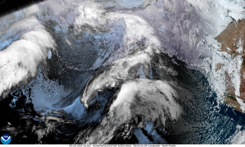
A quick look at the satellite picture paints the weather picture. There is a trough of low pressure over the region that is bringing the area showers and a slight chance of thunderstorms. All this after a couple of fronts over the weekend brought just under an inch of rain to the airport both Saturday and Sunday, with a little over an inch seen in the Coast Range. We saw a few more showers and thunderstorms moving across today that have given the area another quarter to a half inch or so. The rivers did respond with increased flow rates but being as low as they were, the 2-3’ rise did little more than to excite the fishermen. It looks like the unstable air will still be producing rainshowers with possible thunderstorms tonight with westerly winds 5-10, tonight’s low near 41.

We will likely see some partly sunny skies tomorrow as the trough continues to slide to the east with a few more scattered showers still around, especially with daytime heating, the winds swinging around to southerly 4-8, the high near 56. Then more scattered showers are expected to linger tomorrow night, still with the southerly winds, the low drops to near 43.

We have another decent system that will bring us more rain with another front Wednesday, southerly winds 10-15 gusting to 20, the high near 54. After this, we see post-frontal showers and possible thunderstorms with the lagging trough of low pressure, the low near 43.

Sorry Trick or Treaters, Thursday the showers and possible thunderstorms continue as the parent low pressure system is dropping down towards the Oregon coast, which enhances the shower and thunderstorm chance, possibly bringing some gusty afternoon winds also, highs near 54. Look for more of the same Thursday night, lows near 40. This new round of rain and showers does push the rivers up some more, but the river flooding concerns continue to remain low.

More rain is expected for Friday as that low pushes into Oregon, then races northeastward, but leaving a trough of low pressure over the area, so we continue to have a threat of rain or rainshowers Saturday and Sunday as well, though some of the models suggest drier weather could move in.

Is this typical weather for our area you ask? Well, we are almost into November, which is typically wet with several fronts and low pressure systems that bring rain or drizzle, with daily high temperatures in the 40-50 degree range. In the past, some of these fronts have brought us heavy rain and high winds, especially later in the month. We have also seen some flooding in the past from November systems. The most recent one was on November 12th, 2021, when the Wilson River climbed to 14.79’. Many may remember the historic flood of 2006 (the year that I moved to Oregon) when the Wilson River climbed to near 22.84. For the new folks, the Flood Level for the Wilson River is 12’.

Featured Video

Slide Contribute SUBSCRIBE

Tillamook Weather

Tides

Tillamook County Pioneer Podcast Series

Tillamook Church Search

Cloverdale Baptist Church
Nestucca Valley Presbyterian
Tillamook Ecumenical Service

Archives

  • Home
  • EULA Privacy Policy
  • Contact
  • Opt-out preferences
  • Search...
Share on facebook
Facebook
Share on pinterest
Pinterest
Share on twitter
Twitter
Share on linkedin
Linkedin
Catherine

Recent Posts

  • VOTE! VOTE! VOTE! Exercise the Right to Vote - It's More Important Than Ever

    May 15, 2025
  • A PERSONAL POINT OF PRIVILEGE: Democracy Is a Chore, So Let’s Just Appoint a Board

    May 15, 2025
  • GORDON'S WEEKEND WEATHER UPDATE 5/15/25: More showers and slight threat of thunderstorms

    May 15, 2025
©2025 | Theme by SuperbThemes

Manage Cookie Consent
To provide the best experiences, we use technologies like cookies to store and/or access device information. Consenting to these technologies will allow us to process data such as browsing behavior or unique IDs on this site. Not consenting or withdrawing consent, may adversely affect certain features and functions.
Functional Always active
The technical storage or access is strictly necessary for the legitimate purpose of enabling the use of a specific service explicitly requested by the subscriber or user, or for the sole purpose of carrying out the transmission of a communication over an electronic communications network.
Preferences
The technical storage or access is necessary for the legitimate purpose of storing preferences that are not requested by the subscriber or user.
Statistics
The technical storage or access that is used exclusively for statistical purposes. The technical storage or access that is used exclusively for anonymous statistical purposes. Without a subpoena, voluntary compliance on the part of your Internet Service Provider, or additional records from a third party, information stored or retrieved for this purpose alone cannot usually be used to identify you.
Marketing
The technical storage or access is required to create user profiles to send advertising, or to track the user on a website or across several websites for similar marketing purposes.
Manage options Manage services Manage {vendor_count} vendors Read more about these purposes
View preferences
{title} {title} {title}