Menu
  • Home
  • Breaking News
  • Feature
    • Arts
    • Astrology
    • Business
    • Community
    • Employment
    • Event Stories
    • From the Pioneer
    • Government
    • Letters to the Editor
    • Non Profit News
    • Obituary
    • Public Safety
    • Podcast Interview Articles
    • Pioneer Pulse Podcast: Politics, Palette, and Planet – the Playlist
  • Weather
  • Guest Column
    • Perspectives
    • Don Backman Photos
    • Ardent Gourmet
    • Kitchen Maven
    • I’ve been thinking
    • Jim Heffernan
    • The Littoral Life
    • Neal Lemery
    • View From Here
    • Virginia Carrell Prowell
    • Words of Wisdom
  • Things to do
    • Calendar
    • Tillamook County Parks
    • Tillamook County Hikes
    • Whale Watching
    • Tillamook County Library
    • SOS Community Calendar
  • About
    • Contribute
    • Advertise
    • Subscribe
    • Opt-out preferences
  • Post Submission Test
  • Search...
Menu

TILLAMOOK COUNTY EMERGENCY MANAGEMENT: Wet Week Ahead – Weather Forecast 10/27/24

Posted on October 27, 2024October 27, 2024 by Editor

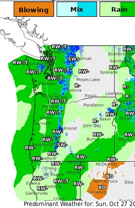
Looks like a wet week ahead…
Detailed Forecast from National Weather Service – 10/27/24:
This Afternoon
Showers likely and possibly a thunderstorm. Mostly cloudy, with a high near 57. Breezy, with a southwest wind around 18 mph, with gusts as high as 24 mph. Chance of precipitation is 70%.
Tonight
Showers and thunderstorms before 4am, then showers likely and possibly a thunderstorm between 4am and 5am, then a chance of showers and thunderstorms after 5am. Low around 44. South southwest wind 9 to 14 mph becoming light south after midnight. Winds could gust as high as 20 mph. Chance of precipitation is 90%. New rainfall amounts between a quarter and half of an inch possible.
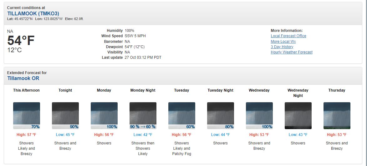
Monday
Showers and thunderstorms before 3pm, then a chance of showers between 3pm and 5pm, then a chance of showers and thunderstorms after 5pm. High near 56. Light southwest wind becoming west 6 to 11 mph in the morning. Chance of precipitation is 100%. New rainfall amounts between a quarter and half of an inch possible.
Monday Night
Showers and possibly a thunderstorm. Low around 41. West northwest wind 5 to 10 mph becoming light northwest after midnight. Chance of precipitation is 90%. New precipitation amounts between a tenth and quarter of an inch, except higher amounts possible in thunderstorms.
Tuesday
Showers likely, mainly after 11am. Patchy fog before 11am. Otherwise, partly sunny, with a high near 56. Calm wind becoming southwest around 6 mph in the afternoon. Chance of precipitation is 60%.
Tuesday Night
Showers, mainly after 11pm. Low around 43. Chance of precipitation is 80%.
Wednesday
Showers. High near 53. Chance of precipitation is 100%.
Wednesday Night
Showers and possibly a thunderstorm. Cloudy, with a low around 42.
Thursday
Showers and possibly a thunderstorm. Cloudy, with a high near 53.
Thursday Night
Showers and possibly a thunderstorm before 11pm, then showers likely. Mostly cloudy, with a low around 42.
Friday
Showers. Mostly cloudy, with a high near 55.
Friday Night
Showers. Mostly cloudy, with a low around 39.
Saturday
A chance of showers. Partly sunny, with a high near 57.
Saturday Night
A chance of showers. Mostly cloudy, with a low around 41.
Sunday
A chance of showers. Partly sunny, with a high near 58.

Featured Video

Slide Contribute SUBSCRIBE

Tillamook Weather

Tides

Tillamook County Pioneer Podcast Series

Tillamook Church Search

Cloverdale Baptist Church
Nestucca Valley Presbyterian
Tillamook Ecumenical Service

Archives

  • Home
  • EULA Privacy Policy
  • Contact
  • Opt-out preferences
  • Search...
Share on facebook
Facebook
Share on pinterest
Pinterest
Share on twitter
Twitter
Share on linkedin
Linkedin
Catherine

Recent Posts

  • Tillamook FFA Excels in State Career Development Events: Two Teams Headed to Nationals

    May 12, 2025
  • Tillamook Police Department Invites Community for Coffee with a Cop May 14th

    May 12, 2025
  • GORDON'S WEEKLY WEATHER UPDATE 5/12/25: Showery Pattern Continues Through Week

    May 12, 2025
©2025 | Theme by SuperbThemes

Manage Cookie Consent
To provide the best experiences, we use technologies like cookies to store and/or access device information. Consenting to these technologies will allow us to process data such as browsing behavior or unique IDs on this site. Not consenting or withdrawing consent, may adversely affect certain features and functions.
Functional Always active
The technical storage or access is strictly necessary for the legitimate purpose of enabling the use of a specific service explicitly requested by the subscriber or user, or for the sole purpose of carrying out the transmission of a communication over an electronic communications network.
Preferences
The technical storage or access is necessary for the legitimate purpose of storing preferences that are not requested by the subscriber or user.
Statistics
The technical storage or access that is used exclusively for statistical purposes. The technical storage or access that is used exclusively for anonymous statistical purposes. Without a subpoena, voluntary compliance on the part of your Internet Service Provider, or additional records from a third party, information stored or retrieved for this purpose alone cannot usually be used to identify you.
Marketing
The technical storage or access is required to create user profiles to send advertising, or to track the user on a website or across several websites for similar marketing purposes.
Manage options Manage services Manage {vendor_count} vendors Read more about these purposes
View preferences
{title} {title} {title}